You are here: Home > Network List > II - Global Seismograph Network (GSN - IRIS/IDA) Stations List
> Station CMLA Cha de Macela, Sao Miguel Island, Azores > Earthquake Result Viewer
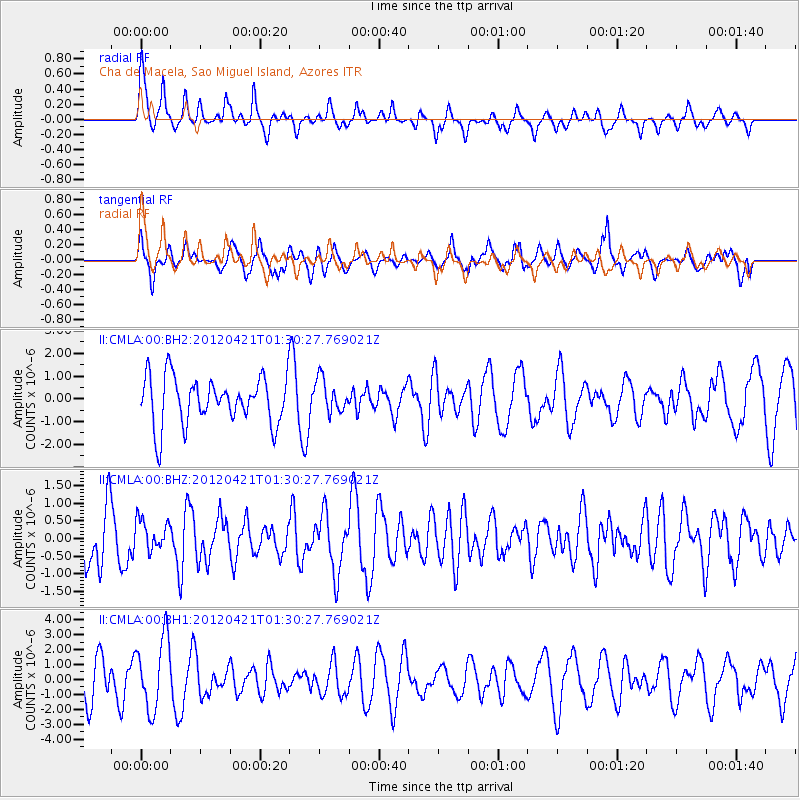
CMLA Cha de Macela, Sao Miguel Island, Azores - Earthquake Result Viewer
*The percent match for this event was below the threshold and hence no stack was calculated.
| Earthquake location: |
Southern Mid-Atlantic Ridge |
| Earthquake latitude/longitude: |
-35.2/-16.2 |
| Earthquake time(UTC): |
2012/04/21 (112) 01:19:28 GMT |
| Earthquake Depth: |
10 km |
| Earthquake Magnitude: |
5.7 MW, 5.0 MB |
| Earthquake Catalog/Contributor: |
WHDF/NEIC |
|
| Network: |
II Global Seismograph Network (GSN - IRIS/IDA) |
| Station: |
CMLA Cha de Macela, Sao Miguel Island, Azores |
| Lat/Lon: |
37.76 N/25.52 W |
| Elevation: |
429 m |
|
| Distance: |
73.1 deg |
| Az: |
352.273 deg |
| Baz: |
172.017 deg |
| Ray Param: |
$rayparam |
*The percent match for this event was below the threshold and hence was not used in the summary stack. |
|
| Radial Match: |
55.71976 % |
| Radial Bump: |
369 |
| Transverse Match: |
69.38601 % |
| Transverse Bump: |
400 |
| SOD ConfigId: |
558545 |
| Insert Time: |
2013-09-19 16:43:22.579 +0000 |
| GWidth: |
2.5 |
| Max Bumps: |
400 |
| Tol: |
0.001 |
|
Signal To Noise
| Channel | StoN | STA | LTA |
| II:CMLA:00:BHZ:20120421T01:30:27.769021Z | 0.5346944 | 4.3213853E-7 | 8.081973E-7 |
| II:CMLA:00:BH1:20120421T01:30:27.769021Z | 2.4879098 | 2.3975697E-6 | 9.636884E-7 |
| II:CMLA:00:BH2:20120421T01:30:27.769021Z | 0.6981691 | 7.300199E-7 | 1.0456205E-6 |
| Arrivals |
| Ps | |
| PpPs | |
| PsPs/PpSs | |


