You are here: Home > Network List > IU - Global Seismograph Network (GSN - IRIS/USGS) Stations List
> Station TEIG Tepich, Yucatan, Mexico > Earthquake Result Viewer
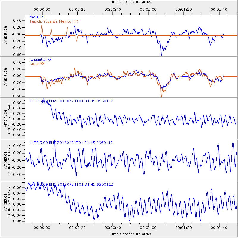
TEIG Tepich, Yucatan, Mexico - Earthquake Result Viewer
*The percent match for this event was below the threshold and hence no stack was calculated.
| Earthquake location: |
Southern Mid-Atlantic Ridge |
| Earthquake latitude/longitude: |
-35.2/-16.2 |
| Earthquake time(UTC): |
2012/04/21 (112) 01:19:28 GMT |
| Earthquake Depth: |
10 km |
| Earthquake Magnitude: |
5.7 MW, 5.0 MB |
| Earthquake Catalog/Contributor: |
WHDF/NEIC |
|
| Network: |
IU Global Seismograph Network (GSN - IRIS/USGS) |
| Station: |
TEIG Tepich, Yucatan, Mexico |
| Lat/Lon: |
20.23 N/88.28 W |
| Elevation: |
40 m |
|
| Distance: |
87.8 deg |
| Az: |
296.584 deg |
| Baz: |
128.775 deg |
| Ray Param: |
$rayparam |
*The percent match for this event was below the threshold and hence was not used in the summary stack. |
|
| Radial Match: |
35.190758 % |
| Radial Bump: |
400 |
| Transverse Match: |
25.517424 % |
| Transverse Bump: |
400 |
| SOD ConfigId: |
558545 |
| Insert Time: |
2013-09-19 16:44:05.047 +0000 |
| GWidth: |
2.5 |
| Max Bumps: |
400 |
| Tol: |
0.001 |
|
Signal To Noise
| Channel | StoN | STA | LTA |
| IU:TEIG:00:BHZ:20120421T01:31:45.996011Z | 1.3002989 | 1.7393153E-7 | 1.3376273E-7 |
| IU:TEIG:00:BH1:20120421T01:31:45.996011Z | 0.9372564 | 1.9768082E-7 | 2.1091435E-7 |
| IU:TEIG:00:BH2:20120421T01:31:45.996011Z | 0.88815325 | 2.4820346E-7 | 2.7946018E-7 |
| Arrivals |
| Ps | |
| PpPs | |
| PsPs/PpSs | |


