You are here: Home > Network List > IU - Global Seismograph Network (GSN - IRIS/USGS) Stations List
> Station SNZO South Karori, New Zealand > Earthquake Result Viewer
SNZO South Karori, New Zealand - Earthquake Result Viewer
| Earthquake location: |
Irian Jaya Region, Indonesia |
| Earthquake latitude/longitude: |
-1.6/134.2 |
| Earthquake time(UTC): |
2012/04/21 (112) 01:25:13 GMT |
| Earthquake Depth: |
17 km |
| Earthquake Magnitude: |
5.6 MB, 6.0 MW |
| Earthquake Catalog/Contributor: |
WHDF/NEIC |
|
| Network: |
IU Global Seismograph Network (GSN - IRIS/USGS) |
| Station: |
SNZO South Karori, New Zealand |
| Lat/Lon: |
41.31 S/174.70 E |
| Elevation: |
120 m |
|
| Distance: |
53.8 deg |
| Az: |
142.647 deg |
| Baz: |
306.386 deg |
| Ray Param: |
0.06586717 |
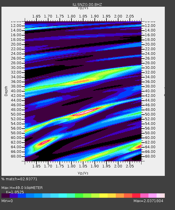
| Estimated Moho Depth: |
49.0 km |
| Estimated Crust Vp/Vs: |
1.85 |
| Assumed Crust Vp: |
6.461 km/s |
| Estimated Crust Vs: |
3.488 km/s |
| Estimated Crust Poisson's Ratio: |
0.29 |
|
| Radial Match: |
82.93771 % |
| Radial Bump: |
400 |
| Transverse Match: |
52.739407 % |
| Transverse Bump: |
400 |
| SOD ConfigId: |
558545 |
| Insert Time: |
2013-09-19 16:46:16.931 +0000 |
| GWidth: |
2.5 |
| Max Bumps: |
400 |
| Tol: |
0.001 |
|
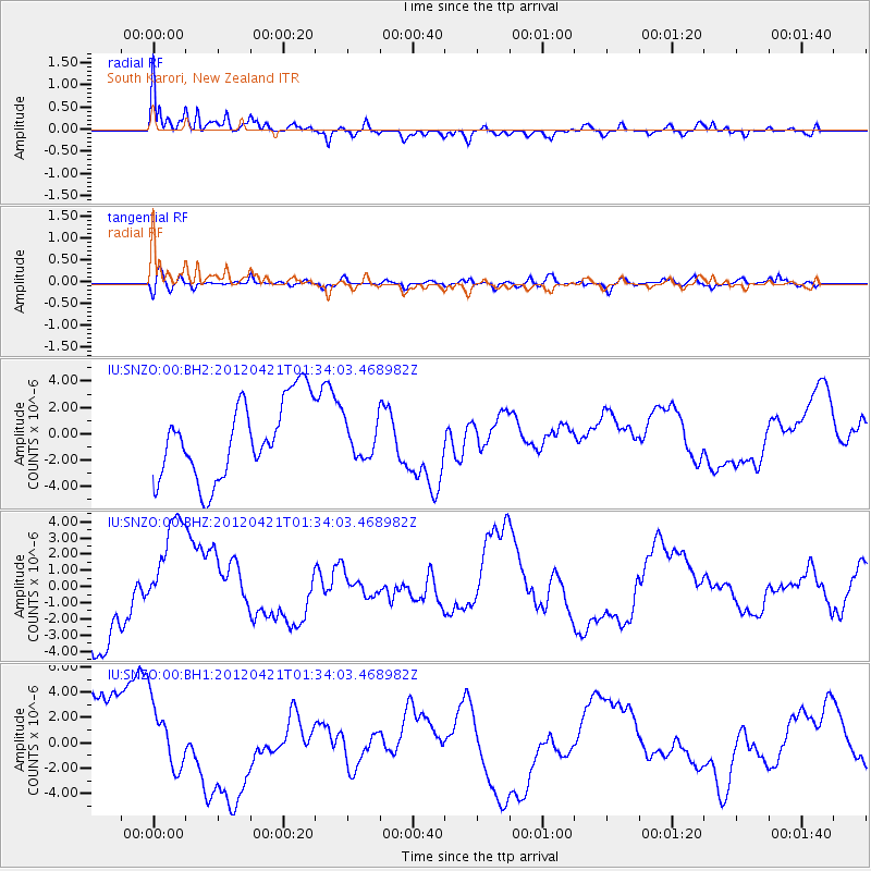
Signal To Noise
| Channel | StoN | STA | LTA |
| IU:SNZO:00:BHZ:20120421T01:34:03.468982Z | 1.4473435 | 3.40947E-6 | 2.3556745E-6 |
| IU:SNZO:00:BH1:20120421T01:34:03.468982Z | 0.8195963 | 2.7608805E-6 | 3.3685858E-6 |
| IU:SNZO:00:BH2:20120421T01:34:03.468982Z | 0.46650657 | 1.3735413E-6 | 2.9443129E-6 |
| Arrivals |
| Ps | 6.8 SECOND |
| PpPs | 21 SECOND |
| PsPs/PpSs | 27 SECOND |


