You are here: Home > Network List > CN - Canadian National Seismograph Network Stations List
> Station PMB Pemberton, British Columbia, Canada > Earthquake Result Viewer
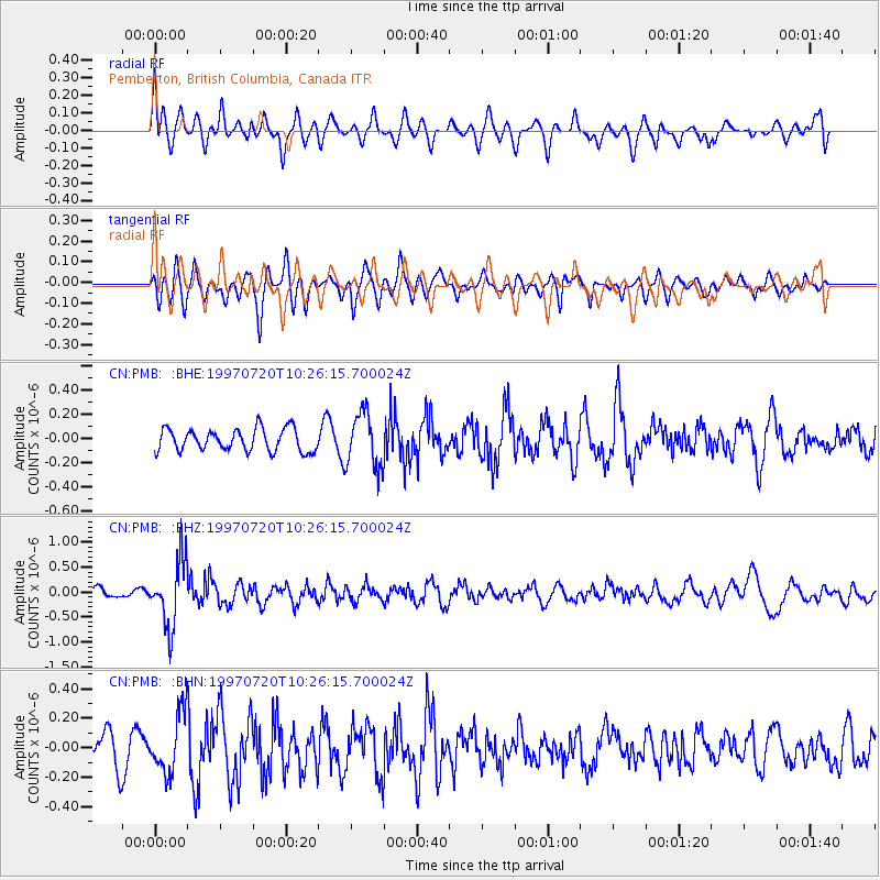
PMB Pemberton, British Columbia, Canada - Earthquake Result Viewer
*The percent match for this event was below the threshold and hence no stack was calculated.
| Earthquake location: |
Jujuy Province, Argentina |
| Earthquake latitude/longitude: |
-23.0/-66.3 |
| Earthquake time(UTC): |
1997/07/20 (201) 10:14:22 GMT |
| Earthquake Depth: |
256 km |
| Earthquake Magnitude: |
5.7 MB, 6.1 UNKNOWN, 5.7 ME |
| Earthquake Catalog/Contributor: |
WHDF/NEIC |
|
| Network: |
CN Canadian National Seismograph Network |
| Station: |
PMB Pemberton, British Columbia, Canada |
| Lat/Lon: |
50.52 N/123.08 W |
| Elevation: |
400 m |
|
| Distance: |
88.7 deg |
| Az: |
327.713 deg |
| Baz: |
129.544 deg |
| Ray Param: |
$rayparam |
*The percent match for this event was below the threshold and hence was not used in the summary stack. |
|
| Radial Match: |
54.959248 % |
| Radial Bump: |
400 |
| Transverse Match: |
56.157085 % |
| Transverse Bump: |
400 |
| SOD ConfigId: |
4480 |
| Insert Time: |
2010-02-27 06:53:35.337 +0000 |
| GWidth: |
2.5 |
| Max Bumps: |
400 |
| Tol: |
0.001 |
|
Signal To Noise
| Channel | StoN | STA | LTA |
| CN:PMB: :BHZ:19970720T10:26:15.700024Z | 6.7877407 | 6.654045E-7 | 9.803034E-8 |
| CN:PMB: :BHN:19970720T10:26:15.700024Z | 1.4705333 | 1.9994076E-7 | 1.359648E-7 |
| CN:PMB: :BHE:19970720T10:26:15.700024Z | 2.4731302 | 2.2771388E-7 | 9.207517E-8 |
| Arrivals |
| Ps | |
| PpPs | |
| PsPs/PpSs | |


