You are here: Home > Network List > IU - Global Seismograph Network (GSN - IRIS/USGS) Stations List
> Station HNR Honiara, Solomon Islands > Earthquake Result Viewer
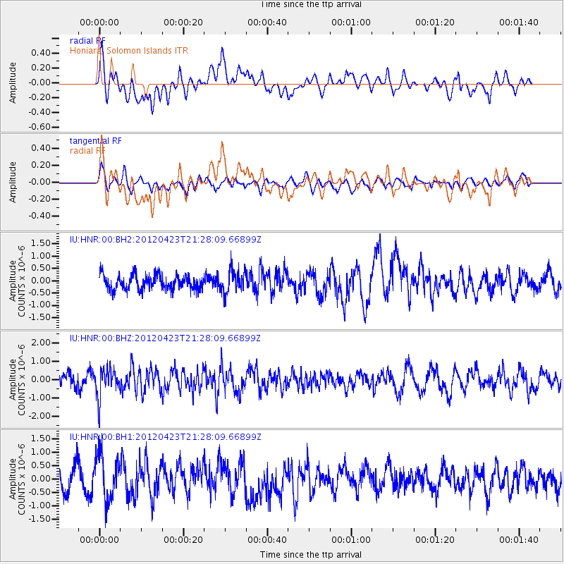
HNR Honiara, Solomon Islands - Earthquake Result Viewer
*The percent match for this event was below the threshold and hence no stack was calculated.
| Earthquake location: |
Northern Molucca Sea |
| Earthquake latitude/longitude: |
0.4/125.3 |
| Earthquake time(UTC): |
2012/04/23 (114) 21:21:44 GMT |
| Earthquake Depth: |
48 km |
| Earthquake Magnitude: |
5.7 MB, 5.0 MS, 5.7 MW, 5.7 MW |
| Earthquake Catalog/Contributor: |
WHDF/NEIC |
|
| Network: |
IU Global Seismograph Network (GSN - IRIS/USGS) |
| Station: |
HNR Honiara, Solomon Islands |
| Lat/Lon: |
9.44 S/159.95 E |
| Elevation: |
100 m |
|
| Distance: |
35.9 deg |
| Az: |
106.687 deg |
| Baz: |
283.871 deg |
| Ray Param: |
$rayparam |
*The percent match for this event was below the threshold and hence was not used in the summary stack. |
|
| Radial Match: |
53.468708 % |
| Radial Bump: |
400 |
| Transverse Match: |
42.81885 % |
| Transverse Bump: |
400 |
| SOD ConfigId: |
558545 |
| Insert Time: |
2013-09-19 16:52:33.641 +0000 |
| GWidth: |
2.5 |
| Max Bumps: |
400 |
| Tol: |
0.001 |
|
Signal To Noise
| Channel | StoN | STA | LTA |
| IU:HNR:00:BHZ:20120423T21:28:09.66899Z | 2.8351028 | 7.9714175E-7 | 2.8116855E-7 |
| IU:HNR:00:BH1:20120423T21:28:09.66899Z | 2.0040927 | 8.471696E-7 | 4.2271978E-7 |
| IU:HNR:00:BH2:20120423T21:28:09.66899Z | 1.5106268 | 4.4030983E-7 | 2.9147492E-7 |
| Arrivals |
| Ps | |
| PpPs | |
| PsPs/PpSs | |


