You are here: Home > Network List > CN - Canadian National Seismograph Network Stations List
> Station PMB Pemberton, British Columbia, Canada > Earthquake Result Viewer
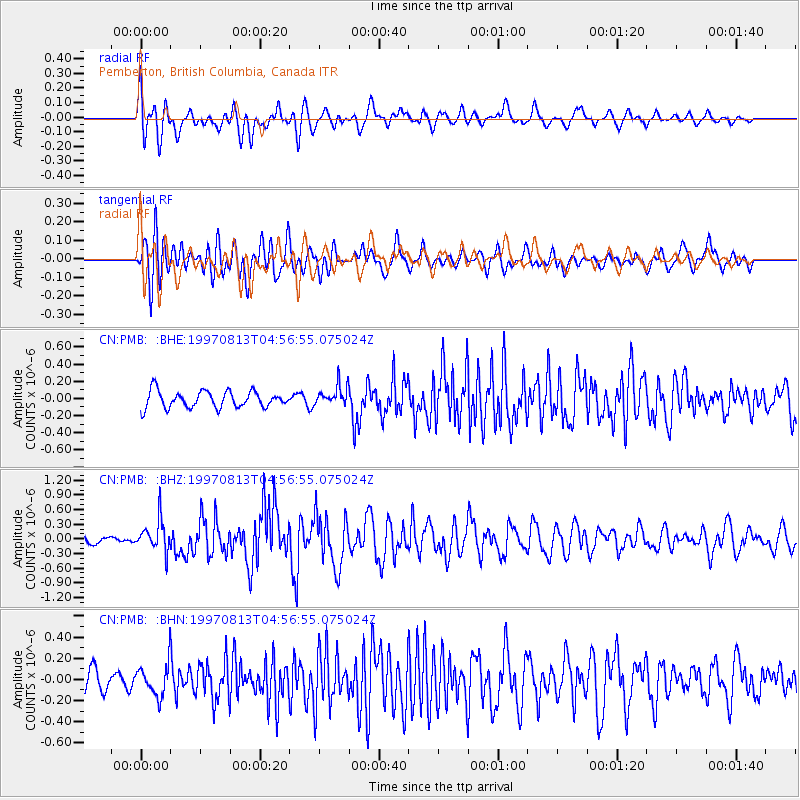
PMB Pemberton, British Columbia, Canada - Earthquake Result Viewer
*The percent match for this event was below the threshold and hence no stack was calculated.
| Earthquake location: |
Southwestern Ryukyu Isl., Japan |
| Earthquake latitude/longitude: |
25.0/125.8 |
| Earthquake time(UTC): |
1997/08/13 (225) 04:45:04 GMT |
| Earthquake Depth: |
55 km |
| Earthquake Magnitude: |
6.0 MB, 5.6 MS, 6.1 UNKNOWN, 6.1 MW |
| Earthquake Catalog/Contributor: |
WHDF/NEIC |
|
| Network: |
CN Canadian National Seismograph Network |
| Station: |
PMB Pemberton, British Columbia, Canada |
| Lat/Lon: |
50.52 N/123.08 W |
| Elevation: |
400 m |
|
| Distance: |
83.4 deg |
| Az: |
36.821 deg |
| Baz: |
301.605 deg |
| Ray Param: |
$rayparam |
*The percent match for this event was below the threshold and hence was not used in the summary stack. |
|
| Radial Match: |
75.49172 % |
| Radial Bump: |
400 |
| Transverse Match: |
73.1053 % |
| Transverse Bump: |
400 |
| SOD ConfigId: |
4480 |
| Insert Time: |
2010-02-27 06:53:42.487 +0000 |
| GWidth: |
2.5 |
| Max Bumps: |
400 |
| Tol: |
0.001 |
|
Signal To Noise
| Channel | StoN | STA | LTA |
| CN:PMB: :BHZ:19970813T04:56:55.075024Z | 4.5377398 | 3.1871417E-7 | 7.0236325E-8 |
| CN:PMB: :BHN:19970813T04:56:55.075024Z | 1.6373764 | 1.482844E-7 | 9.0562196E-8 |
| CN:PMB: :BHE:19970813T04:56:55.075024Z | 1.2132201 | 1.1688711E-7 | 9.634452E-8 |
| Arrivals |
| Ps | |
| PpPs | |
| PsPs/PpSs | |


