You are here: Home > Network List > CN - Canadian National Seismograph Network Stations List
> Station PMB Pemberton, British Columbia, Canada > Earthquake Result Viewer
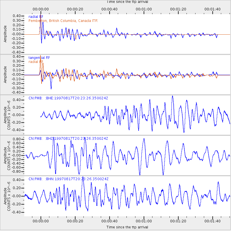
PMB Pemberton, British Columbia, Canada - Earthquake Result Viewer
*The percent match for this event was below the threshold and hence no stack was calculated.
| Earthquake location: |
Vanuatu Islands |
| Earthquake latitude/longitude: |
-13.6/167.4 |
| Earthquake time(UTC): |
1997/08/17 (229) 20:11:10 GMT |
| Earthquake Depth: |
26 km |
| Earthquake Magnitude: |
5.4 MB, 6.1 MS, 6.1 UNKNOWN, 6.0 MW |
| Earthquake Catalog/Contributor: |
WHDF/NEIC |
|
| Network: |
CN Canadian National Seismograph Network |
| Station: |
PMB Pemberton, British Columbia, Canada |
| Lat/Lon: |
50.52 N/123.08 W |
| Elevation: |
400 m |
|
| Distance: |
87.9 deg |
| Az: |
36.761 deg |
| Baz: |
245.728 deg |
| Ray Param: |
$rayparam |
*The percent match for this event was below the threshold and hence was not used in the summary stack. |
|
| Radial Match: |
61.694717 % |
| Radial Bump: |
400 |
| Transverse Match: |
78.077644 % |
| Transverse Bump: |
400 |
| SOD ConfigId: |
4480 |
| Insert Time: |
2010-02-27 06:53:45.759 +0000 |
| GWidth: |
2.5 |
| Max Bumps: |
400 |
| Tol: |
0.001 |
|
Signal To Noise
| Channel | StoN | STA | LTA |
| CN:PMB: :BHZ:19970817T20:23:26.350024Z | 1.3802088 | 9.700465E-8 | 7.028259E-8 |
| CN:PMB: :BHN:19970817T20:23:26.350024Z | 1.7972034 | 1.04687196E-7 | 5.8250055E-8 |
| CN:PMB: :BHE:19970817T20:23:26.350024Z | 1.1763706 | 6.945932E-8 | 5.9045437E-8 |
| Arrivals |
| Ps | |
| PpPs | |
| PsPs/PpSs | |


