You are here: Home > Network List > CN - Canadian National Seismograph Network Stations List
> Station PMB Pemberton, British Columbia, Canada > Earthquake Result Viewer
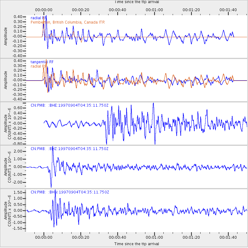
PMB Pemberton, British Columbia, Canada - Earthquake Result Viewer
*The percent match for this event was below the threshold and hence no stack was calculated.
| Earthquake location: |
South Of Fiji Islands |
| Earthquake latitude/longitude: |
-26.6/178.3 |
| Earthquake time(UTC): |
1997/09/04 (247) 04:23:37 GMT |
| Earthquake Depth: |
625 km |
| Earthquake Magnitude: |
6.3 MB, 6.8 UNKNOWN, 6.5 ME |
| Earthquake Catalog/Contributor: |
WHDF/NEIC |
|
| Network: |
CN Canadian National Seismograph Network |
| Station: |
PMB Pemberton, British Columbia, Canada |
| Lat/Lon: |
50.52 N/123.08 W |
| Elevation: |
400 m |
|
| Distance: |
92.5 deg |
| Az: |
33.048 deg |
| Baz: |
229.915 deg |
| Ray Param: |
$rayparam |
*The percent match for this event was below the threshold and hence was not used in the summary stack. |
|
| Radial Match: |
80.645676 % |
| Radial Bump: |
400 |
| Transverse Match: |
78.933556 % |
| Transverse Bump: |
400 |
| SOD ConfigId: |
4480 |
| Insert Time: |
2010-02-27 06:53:46.775 +0000 |
| GWidth: |
2.5 |
| Max Bumps: |
400 |
| Tol: |
0.001 |
|
Signal To Noise
| Channel | StoN | STA | LTA |
| CN:PMB: :BHZ:19970904T04:35:11.750Z | 11.516721 | 9.680274E-7 | 8.405408E-8 |
| CN:PMB: :BHN:19970904T04:35:11.750Z | 2.6198957 | 2.6324238E-7 | 1.0047819E-7 |
| CN:PMB: :BHE:19970904T04:35:11.750Z | 3.6218667 | 2.6148808E-7 | 7.219705E-8 |
| Arrivals |
| Ps | |
| PpPs | |
| PsPs/PpSs | |


