You are here: Home > Network List > US - United States National Seismic Network Stations List
> Station DGMT Dagmar, Montana, USA > Earthquake Result Viewer
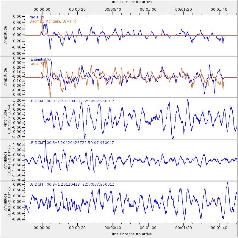
DGMT Dagmar, Montana, USA - Earthquake Result Viewer
*The percent match for this event was below the threshold and hence no stack was calculated.
| Earthquake location: |
Kuril Islands |
| Earthquake latitude/longitude: |
48.4/154.7 |
| Earthquake time(UTC): |
2012/04/23 (114) 22:40:22 GMT |
| Earthquake Depth: |
31 km |
| Earthquake Magnitude: |
5.6 MW, 5.2 MS, 5.4 MB, 5.7 MW |
| Earthquake Catalog/Contributor: |
WHDF/NEIC |
|
| Network: |
US United States National Seismic Network |
| Station: |
DGMT Dagmar, Montana, USA |
| Lat/Lon: |
48.47 N/104.20 W |
| Elevation: |
0.0 m |
|
| Distance: |
61.9 deg |
| Az: |
47.778 deg |
| Baz: |
312.131 deg |
| Ray Param: |
$rayparam |
*The percent match for this event was below the threshold and hence was not used in the summary stack. |
|
| Radial Match: |
54.768353 % |
| Radial Bump: |
400 |
| Transverse Match: |
68.83096 % |
| Transverse Bump: |
400 |
| SOD ConfigId: |
558545 |
| Insert Time: |
2013-09-19 16:56:37.385 +0000 |
| GWidth: |
2.5 |
| Max Bumps: |
400 |
| Tol: |
0.001 |
|
Signal To Noise
| Channel | StoN | STA | LTA |
| US:DGMT:00:BHZ:20120423T22:50:07.95001Z | 2.7170527 | 6.70981E-7 | 2.469518E-7 |
| US:DGMT:00:BH1:20120423T22:50:07.95001Z | 0.44072622 | 1.5343225E-7 | 3.4813505E-7 |
| US:DGMT:00:BH2:20120423T22:50:07.95001Z | 1.4078455 | 7.024362E-7 | 4.989441E-7 |
| Arrivals |
| Ps | |
| PpPs | |
| PsPs/PpSs | |


