You are here: Home > Network List > CN - Canadian National Seismograph Network Stations List
> Station PMB Pemberton, British Columbia, Canada > Earthquake Result Viewer
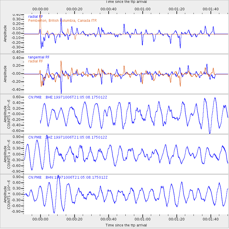
PMB Pemberton, British Columbia, Canada - Earthquake Result Viewer
*The percent match for this event was below the threshold and hence no stack was calculated.
| Earthquake location: |
Solomon Islands |
| Earthquake latitude/longitude: |
-9.3/158.7 |
| Earthquake time(UTC): |
1997/10/06 (279) 20:52:44 GMT |
| Earthquake Depth: |
33 km |
| Earthquake Magnitude: |
5.7 MB, 5.9 MS, 6.1 UNKNOWN, 6.1 MW |
| Earthquake Catalog/Contributor: |
WHDF/NEIC |
|
| Network: |
CN Canadian National Seismograph Network |
| Station: |
PMB Pemberton, British Columbia, Canada |
| Lat/Lon: |
50.52 N/123.08 W |
| Elevation: |
400 m |
|
| Distance: |
89.7 deg |
| Az: |
38.679 deg |
| Baz: |
255.081 deg |
| Ray Param: |
$rayparam |
*The percent match for this event was below the threshold and hence was not used in the summary stack. |
|
| Radial Match: |
71.211044 % |
| Radial Bump: |
400 |
| Transverse Match: |
75.60789 % |
| Transverse Bump: |
338 |
| SOD ConfigId: |
4480 |
| Insert Time: |
2010-02-27 06:53:51.241 +0000 |
| GWidth: |
2.5 |
| Max Bumps: |
400 |
| Tol: |
0.001 |
|
Signal To Noise
| Channel | StoN | STA | LTA |
| CN:PMB: :BHZ:19971006T21:05:08.175012Z | 2.1842227 | 6.034463E-7 | 2.762751E-7 |
| CN:PMB: :BHN:19971006T21:05:08.175012Z | 2.5186253 | 3.8346684E-7 | 1.5225244E-7 |
| CN:PMB: :BHE:19971006T21:05:08.175012Z | 1.4861853 | 3.1733018E-7 | 2.1351993E-7 |
| Arrivals |
| Ps | |
| PpPs | |
| PsPs/PpSs | |


