You are here: Home > Network List > US - United States National Seismic Network Stations List
> Station MSO Missoula, Montana, USA > Earthquake Result Viewer
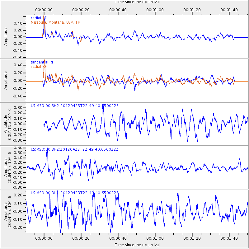
MSO Missoula, Montana, USA - Earthquake Result Viewer
*The percent match for this event was below the threshold and hence no stack was calculated.
| Earthquake location: |
Kuril Islands |
| Earthquake latitude/longitude: |
48.4/154.7 |
| Earthquake time(UTC): |
2012/04/23 (114) 22:40:22 GMT |
| Earthquake Depth: |
31 km |
| Earthquake Magnitude: |
5.6 MW, 5.2 MS, 5.4 MB, 5.7 MW |
| Earthquake Catalog/Contributor: |
WHDF/NEIC |
|
| Network: |
US United States National Seismic Network |
| Station: |
MSO Missoula, Montana, USA |
| Lat/Lon: |
46.83 N/113.94 W |
| Elevation: |
1264 m |
|
| Distance: |
57.9 deg |
| Az: |
54.131 deg |
| Baz: |
308.134 deg |
| Ray Param: |
$rayparam |
*The percent match for this event was below the threshold and hence was not used in the summary stack. |
|
| Radial Match: |
63.229656 % |
| Radial Bump: |
400 |
| Transverse Match: |
46.6339 % |
| Transverse Bump: |
400 |
| SOD ConfigId: |
558545 |
| Insert Time: |
2013-09-19 16:57:17.299 +0000 |
| GWidth: |
2.5 |
| Max Bumps: |
400 |
| Tol: |
0.001 |
|
Signal To Noise
| Channel | StoN | STA | LTA |
| US:MSO:00:BHZ:20120423T22:49:40.650022Z | 5.4824734 | 3.0382319E-7 | 5.5417175E-8 |
| US:MSO:00:BH1:20120423T22:49:40.650022Z | 0.8030335 | 8.543698E-8 | 1.06392804E-7 |
| US:MSO:00:BH2:20120423T22:49:40.650022Z | 2.2288716 | 1.7253446E-7 | 7.7408885E-8 |
| Arrivals |
| Ps | |
| PpPs | |
| PsPs/PpSs | |


