You are here: Home > Network List > CN - Canadian National Seismograph Network Stations List
> Station PMB Pemberton, British Columbia, Canada > Earthquake Result Viewer
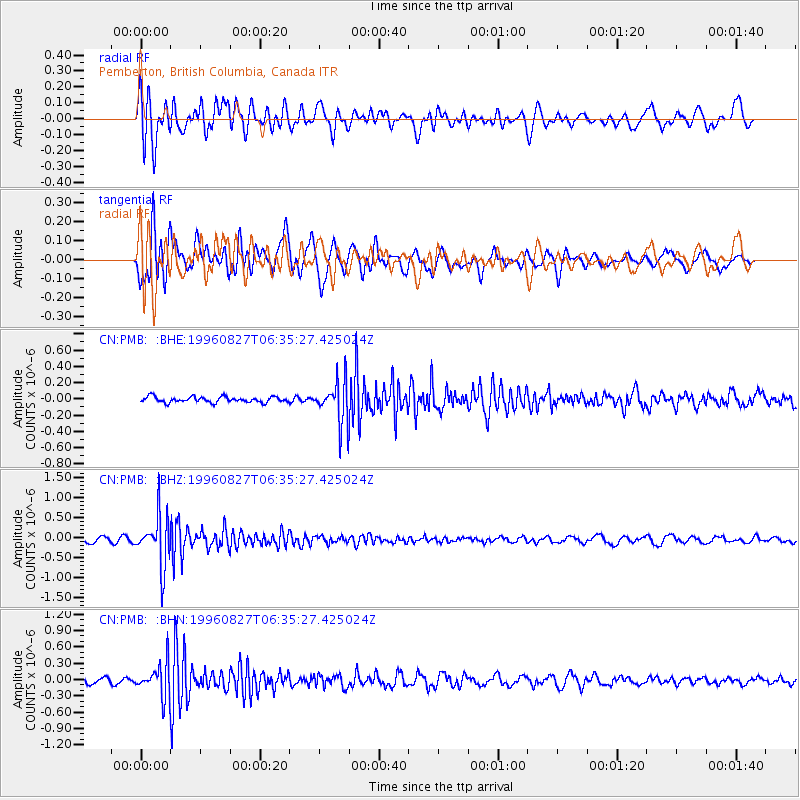
PMB Pemberton, British Columbia, Canada - Earthquake Result Viewer
*The percent match for this event was below the threshold and hence no stack was calculated.
| Earthquake location: |
South Of Fiji Islands |
| Earthquake latitude/longitude: |
-22.6/-179.8 |
| Earthquake time(UTC): |
1996/08/27 (240) 06:24:07 GMT |
| Earthquake Depth: |
575 km |
| Earthquake Magnitude: |
5.6 MB, 6.0 UNKNOWN, 5.5 MB |
| Earthquake Catalog/Contributor: |
WHDF/NEIC |
|
| Network: |
CN Canadian National Seismograph Network |
| Station: |
PMB Pemberton, British Columbia, Canada |
| Lat/Lon: |
50.52 N/123.08 W |
| Elevation: |
400 m |
|
| Distance: |
88.3 deg |
| Az: |
32.269 deg |
| Baz: |
230.628 deg |
| Ray Param: |
$rayparam |
*The percent match for this event was below the threshold and hence was not used in the summary stack. |
|
| Radial Match: |
73.17353 % |
| Radial Bump: |
400 |
| Transverse Match: |
69.44208 % |
| Transverse Bump: |
400 |
| SOD ConfigId: |
4480 |
| Insert Time: |
2010-02-27 06:53:59.436 +0000 |
| GWidth: |
2.5 |
| Max Bumps: |
400 |
| Tol: |
0.001 |
|
Signal To Noise
| Channel | StoN | STA | LTA |
| CN:PMB: :BHZ:19960827T06:35:27.425024Z | 8.94793 | 6.333704E-7 | 7.078402E-8 |
| CN:PMB: :BHN:19960827T06:35:27.425024Z | 6.4092355 | 3.0103078E-7 | 4.6968285E-8 |
| CN:PMB: :BHE:19960827T06:35:27.425024Z | 7.4770207 | 2.5972716E-7 | 3.4736715E-8 |
| Arrivals |
| Ps | |
| PpPs | |
| PsPs/PpSs | |


