You are here: Home > Network List > IU - Global Seismograph Network (GSN - IRIS/USGS) Stations List
> Station PMG Port Moresby, New Guinea > Earthquake Result Viewer
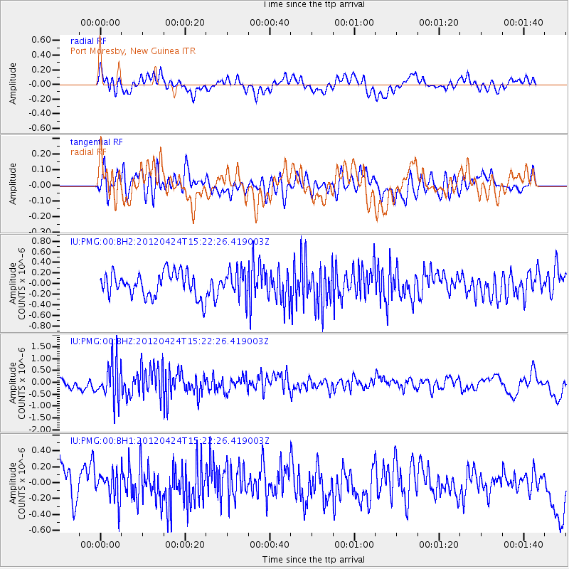
PMG Port Moresby, New Guinea - Earthquake Result Viewer
*The percent match for this event was below the threshold and hence no stack was calculated.
| Earthquake location: |
South Of Tonga Islands |
| Earthquake latitude/longitude: |
-24.2/-175.9 |
| Earthquake time(UTC): |
2012/04/24 (115) 15:15:38 GMT |
| Earthquake Depth: |
10 km |
| Earthquake Magnitude: |
5.6 MW, 5.6 MW, 5.6 MS |
| Earthquake Catalog/Contributor: |
NEIC PDE/NEIC PDE-M |
|
| Network: |
IU Global Seismograph Network (GSN - IRIS/USGS) |
| Station: |
PMG Port Moresby, New Guinea |
| Lat/Lon: |
9.40 S/147.16 E |
| Elevation: |
90 m |
|
| Distance: |
38.1 deg |
| Az: |
286.356 deg |
| Baz: |
117.405 deg |
| Ray Param: |
$rayparam |
*The percent match for this event was below the threshold and hence was not used in the summary stack. |
|
| Radial Match: |
67.142975 % |
| Radial Bump: |
400 |
| Transverse Match: |
49.02109 % |
| Transverse Bump: |
400 |
| SOD ConfigId: |
558545 |
| Insert Time: |
2013-09-19 17:03:15.676 +0000 |
| GWidth: |
2.5 |
| Max Bumps: |
400 |
| Tol: |
0.001 |
|
Signal To Noise
| Channel | StoN | STA | LTA |
| IU:PMG:00:BHZ:20120424T15:22:26.419003Z | 4.2197614 | 8.123019E-7 | 1.9249948E-7 |
| IU:PMG:00:BH1:20120424T15:22:26.419003Z | 0.8076806 | 1.7919146E-7 | 2.218593E-7 |
| IU:PMG:00:BH2:20120424T15:22:26.419003Z | 1.1042262 | 2.5321862E-7 | 2.2931769E-7 |
| Arrivals |
| Ps | |
| PpPs | |
| PsPs/PpSs | |


