You are here: Home > Network List > AU - Australian Seismological Centre Stations List
> Station PSAB3 Pilbara Seismic Array Element B3 > Earthquake Result Viewer
PSAB3 Pilbara Seismic Array Element B3 - Earthquake Result Viewer
| Earthquake location: |
Tonga Islands |
| Earthquake latitude/longitude: |
-18.7/-174.7 |
| Earthquake time(UTC): |
2012/04/28 (119) 10:08:08 GMT |
| Earthquake Depth: |
135 km |
| Earthquake Magnitude: |
6.7 MW, 6.4 MB, 6.6 MW |
| Earthquake Catalog/Contributor: |
NEIC PDE/NEIC PDE-M |
|
| Network: |
AU Australian Seismological Centre |
| Station: |
PSAB3 Pilbara Seismic Array Element B3 |
| Lat/Lon: |
21.59 S/119.85 E |
| Elevation: |
327 m |
|
| Distance: |
61.1 deg |
| Az: |
255.199 deg |
| Baz: |
100.011 deg |
| Ray Param: |
0.060696904 |
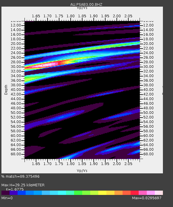
| Estimated Moho Depth: |
29.25 km |
| Estimated Crust Vp/Vs: |
1.68 |
| Assumed Crust Vp: |
6.464 km/s |
| Estimated Crust Vs: |
3.853 km/s |
| Estimated Crust Poisson's Ratio: |
0.22 |
|
| Radial Match: |
89.375496 % |
| Radial Bump: |
320 |
| Transverse Match: |
83.022095 % |
| Transverse Bump: |
400 |
| SOD ConfigId: |
558545 |
| Insert Time: |
2013-09-19 17:13:33.539 +0000 |
| GWidth: |
2.5 |
| Max Bumps: |
400 |
| Tol: |
0.001 |
|

Signal To Noise
| Channel | StoN | STA | LTA |
| AU:PSAB3:00:BHZ:20120428T10:17:37.243992Z | 9.351114 | 2.8141303E-6 | 3.0094066E-7 |
| AU:PSAB3:00:BH1:20120428T10:17:37.243992Z | 6.6367764 | 1.2838057E-6 | 1.9343813E-7 |
| AU:PSAB3:00:BH2:20120428T10:17:37.243992Z | 1.1324393 | 1.7540596E-7 | 1.5489216E-7 |
| Arrivals |
| Ps | 3.2 SECOND |
| PpPs | 12 SECOND |
| PsPs/PpSs | 15 SECOND |


