You are here: Home > Network List > IU - Global Seismograph Network (GSN - IRIS/USGS) Stations List
> Station GUMO Guam, Mariana Islands > Earthquake Result Viewer
GUMO Guam, Mariana Islands - Earthquake Result Viewer
| Earthquake location: |
Tonga Islands |
| Earthquake latitude/longitude: |
-18.7/-174.7 |
| Earthquake time(UTC): |
2012/04/28 (119) 10:08:08 GMT |
| Earthquake Depth: |
135 km |
| Earthquake Magnitude: |
6.7 MW, 6.4 MB, 6.6 MW |
| Earthquake Catalog/Contributor: |
NEIC PDE/NEIC PDE-M |
|
| Network: |
IU Global Seismograph Network (GSN - IRIS/USGS) |
| Station: |
GUMO Guam, Mariana Islands |
| Lat/Lon: |
13.59 N/144.87 E |
| Elevation: |
170 m |
|
| Distance: |
51.1 deg |
| Az: |
305.935 deg |
| Baz: |
127.875 deg |
| Ray Param: |
0.06714489 |
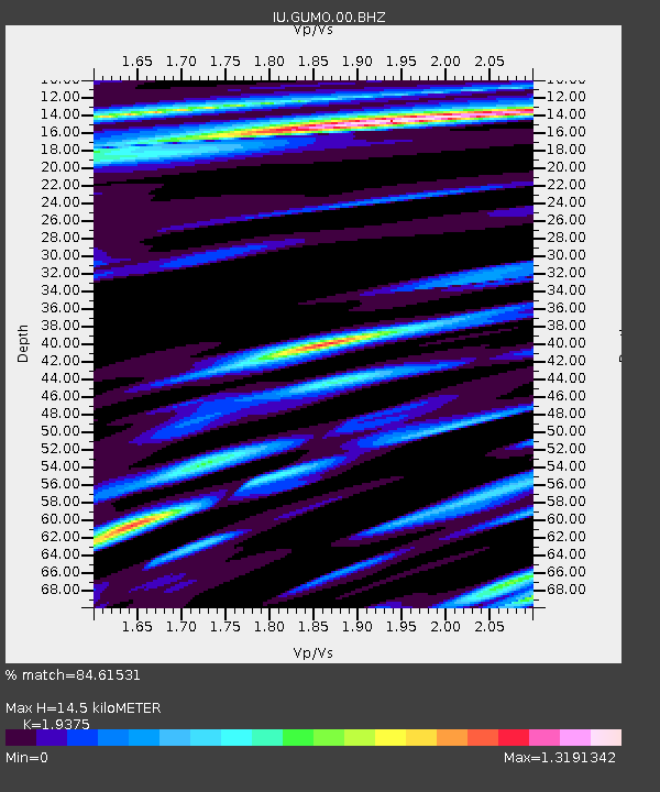
| Estimated Moho Depth: |
14.5 km |
| Estimated Crust Vp/Vs: |
1.94 |
| Assumed Crust Vp: |
4.802 km/s |
| Estimated Crust Vs: |
2.478 km/s |
| Estimated Crust Poisson's Ratio: |
0.32 |
|
| Radial Match: |
84.61531 % |
| Radial Bump: |
400 |
| Transverse Match: |
80.153656 % |
| Transverse Bump: |
400 |
| SOD ConfigId: |
558545 |
| Insert Time: |
2013-09-19 17:14:41.790 +0000 |
| GWidth: |
2.5 |
| Max Bumps: |
400 |
| Tol: |
0.001 |
|

Signal To Noise
| Channel | StoN | STA | LTA |
| IU:GUMO:00:BHZ:20120428T10:16:26.718998Z | 9.16299 | 7.175257E-6 | 7.830694E-7 |
| IU:GUMO:00:BH1:20120428T10:16:26.718998Z | 3.3012395 | 2.1705553E-6 | 6.574971E-7 |
| IU:GUMO:00:BH2:20120428T10:16:26.718998Z | 2.4952137 | 1.841932E-6 | 7.381861E-7 |
| Arrivals |
| Ps | 2.9 SECOND |
| PpPs | 8.6 SECOND |
| PsPs/PpSs | 12 SECOND |


