You are here: Home > Network List > IU - Global Seismograph Network (GSN - IRIS/USGS) Stations List
> Station MBWA Marble Bar, Western Australia > Earthquake Result Viewer
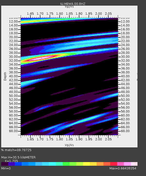
MBWA Marble Bar, Western Australia - Earthquake Result Viewer
| Earthquake location: |
Tonga Islands |
| Earthquake latitude/longitude: |
-18.7/-174.7 |
| Earthquake time(UTC): |
2012/04/28 (119) 10:08:08 GMT |
| Earthquake Depth: |
135 km |
| Earthquake Magnitude: |
6.7 MW, 6.4 MB, 6.6 MW |
| Earthquake Catalog/Contributor: |
NEIC PDE/NEIC PDE-M |
|
| Network: |
IU Global Seismograph Network (GSN - IRIS/USGS) |
| Station: |
MBWA Marble Bar, Western Australia |
| Lat/Lon: |
21.16 S/119.73 E |
| Elevation: |
190 m |
|
| Distance: |
61.3 deg |
| Az: |
255.662 deg |
| Baz: |
100.279 deg |
| Ray Param: |
0.06057796 |
| Estimated Moho Depth: |
30.5 km |
| Estimated Crust Vp/Vs: |
1.71 |
| Assumed Crust Vp: |
6.464 km/s |
| Estimated Crust Vs: |
3.791 km/s |
| Estimated Crust Poisson's Ratio: |
0.24 |
|
| Radial Match: |
89.78725 % |
| Radial Bump: |
394 |
| Transverse Match: |
65.05345 % |
| Transverse Bump: |
400 |
| SOD ConfigId: |
558545 |
| Insert Time: |
2013-09-19 17:14:53.410 +0000 |
| GWidth: |
2.5 |
| Max Bumps: |
400 |
| Tol: |
0.001 |
|

Signal To Noise
| Channel | StoN | STA | LTA |
| IU:MBWA:00:BHZ:20120428T10:17:38.519016Z | 5.6071687 | 2.769845E-6 | 4.939828E-7 |
| IU:MBWA:00:BH1:20120428T10:17:38.519016Z | 9.048509 | 1.0467999E-6 | 1.1568756E-7 |
| IU:MBWA:00:BH2:20120428T10:17:38.519016Z | 1.7409441 | 6.7338794E-7 | 3.8679468E-7 |
| Arrivals |
| Ps | 3.5 SECOND |
| PpPs | 12 SECOND |
| PsPs/PpSs | 16 SECOND |


