You are here: Home > Network List > US - United States National Seismic Network Stations List
> Station AMTX Amarillo, Texas, USA > Earthquake Result Viewer
AMTX Amarillo, Texas, USA - Earthquake Result Viewer
| Earthquake location: |
Tonga Islands |
| Earthquake latitude/longitude: |
-18.7/-174.7 |
| Earthquake time(UTC): |
2012/04/28 (119) 10:08:08 GMT |
| Earthquake Depth: |
135 km |
| Earthquake Magnitude: |
6.7 MW, 6.4 MB, 6.6 MW |
| Earthquake Catalog/Contributor: |
NEIC PDE/NEIC PDE-M |
|
| Network: |
US United States National Seismic Network |
| Station: |
AMTX Amarillo, Texas, USA |
| Lat/Lon: |
34.53 N/101.41 W |
| Elevation: |
1010 m |
|
| Distance: |
87.4 deg |
| Az: |
52.333 deg |
| Baz: |
245.351 deg |
| Ray Param: |
0.043053564 |
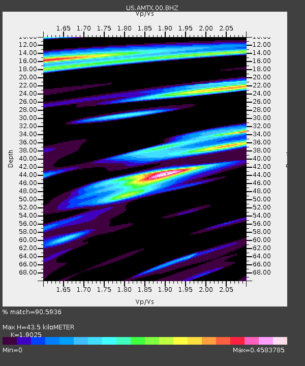
| Estimated Moho Depth: |
43.5 km |
| Estimated Crust Vp/Vs: |
1.90 |
| Assumed Crust Vp: |
6.426 km/s |
| Estimated Crust Vs: |
3.378 km/s |
| Estimated Crust Poisson's Ratio: |
0.31 |
|
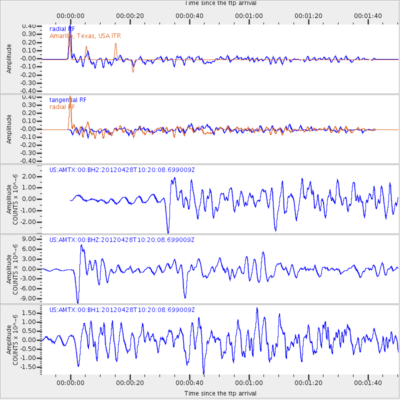
| Radial Match: |
90.5936 % |
| Radial Bump: |
400 |
| Transverse Match: |
70.5802 % |
| Transverse Bump: |
400 |
| SOD ConfigId: |
558545 |
| Insert Time: |
2013-09-19 17:15:46.358 +0000 |
| GWidth: |
2.5 |
| Max Bumps: |
400 |
| Tol: |
0.001 |
|
Signal To Noise
| Channel | StoN | STA | LTA |
| US:AMTX:00:BHZ:20120428T10:20:08.699009Z | 26.620867 | 4.9878613E-6 | 1.8736661E-7 |
| US:AMTX:00:BH1:20120428T10:20:08.699009Z | 2.4077275 | 6.6232985E-7 | 2.7508509E-7 |
| US:AMTX:00:BH2:20120428T10:20:08.699009Z | 7.0200334 | 1.3498113E-6 | 1.922799E-7 |
| Arrivals |
| Ps | 6.2 SECOND |
| PpPs | 19 SECOND |
| PsPs/PpSs | 25 SECOND |


