You are here: Home > Network List > US - United States National Seismic Network Stations List
> Station DGMT Dagmar, Montana, USA > Earthquake Result Viewer
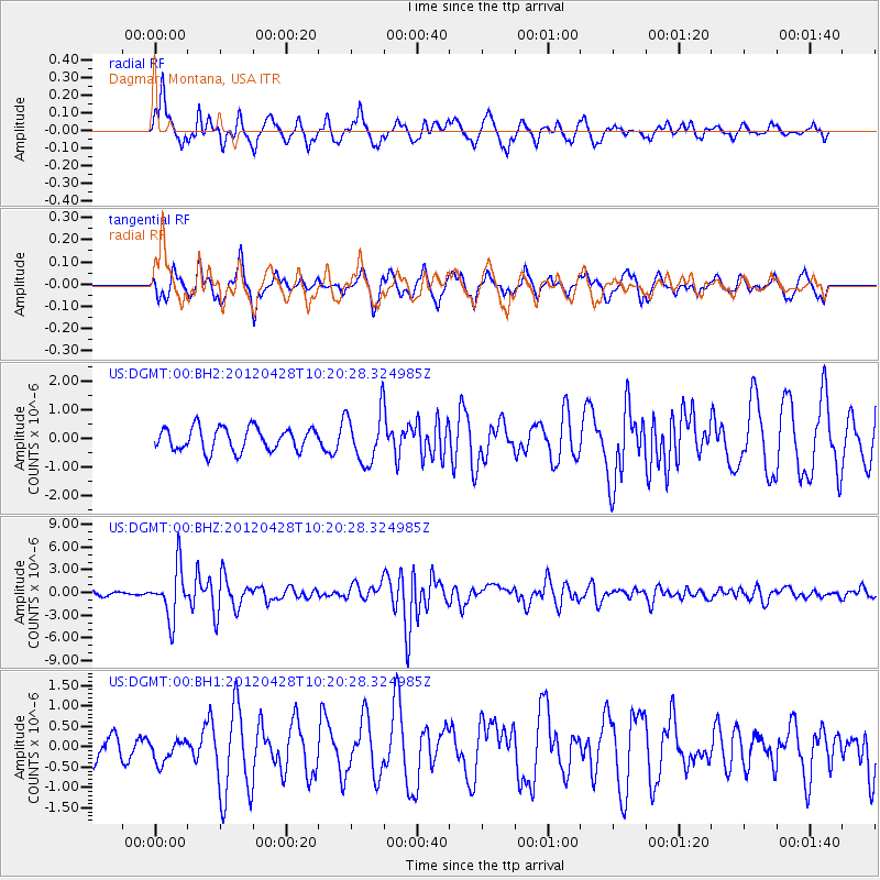
DGMT Dagmar, Montana, USA - Earthquake Result Viewer
*The percent match for this event was below the threshold and hence no stack was calculated.
| Earthquake location: |
Tonga Islands |
| Earthquake latitude/longitude: |
-18.7/-174.7 |
| Earthquake time(UTC): |
2012/04/28 (119) 10:08:08 GMT |
| Earthquake Depth: |
135 km |
| Earthquake Magnitude: |
6.7 MW, 6.4 MB, 6.6 MW |
| Earthquake Catalog/Contributor: |
NEIC PDE/NEIC PDE-M |
|
| Network: |
US United States National Seismic Network |
| Station: |
DGMT Dagmar, Montana, USA |
| Lat/Lon: |
48.47 N/104.20 W |
| Elevation: |
0.0 m |
|
| Distance: |
91.6 deg |
| Az: |
38.873 deg |
| Baz: |
243.375 deg |
| Ray Param: |
$rayparam |
*The percent match for this event was below the threshold and hence was not used in the summary stack. |
|
| Radial Match: |
71.70837 % |
| Radial Bump: |
347 |
| Transverse Match: |
52.64734 % |
| Transverse Bump: |
336 |
| SOD ConfigId: |
558545 |
| Insert Time: |
2013-09-19 17:16:01.827 +0000 |
| GWidth: |
2.5 |
| Max Bumps: |
400 |
| Tol: |
0.001 |
|
Signal To Noise
| Channel | StoN | STA | LTA |
| US:DGMT:00:BHZ:20120428T10:20:28.324985Z | 13.024487 | 3.3065487E-6 | 2.5387172E-7 |
| US:DGMT:00:BH1:20120428T10:20:28.324985Z | 0.66823965 | 2.845335E-7 | 4.257956E-7 |
| US:DGMT:00:BH2:20120428T10:20:28.324985Z | 2.2143242 | 8.8465737E-7 | 3.9951573E-7 |
| Arrivals |
| Ps | |
| PpPs | |
| PsPs/PpSs | |


