You are here: Home > Network List > US - United States National Seismic Network Stations List
> Station HAWA Hanford, Washington, USA > Earthquake Result Viewer
HAWA Hanford, Washington, USA - Earthquake Result Viewer
| Earthquake location: |
Tonga Islands |
| Earthquake latitude/longitude: |
-18.7/-174.7 |
| Earthquake time(UTC): |
2012/04/28 (119) 10:08:08 GMT |
| Earthquake Depth: |
135 km |
| Earthquake Magnitude: |
6.7 MW, 6.4 MB, 6.6 MW |
| Earthquake Catalog/Contributor: |
NEIC PDE/NEIC PDE-M |
|
| Network: |
US United States National Seismic Network |
| Station: |
HAWA Hanford, Washington, USA |
| Lat/Lon: |
46.39 N/119.53 W |
| Elevation: |
364 m |
|
| Distance: |
81.7 deg |
| Az: |
35.045 deg |
| Baz: |
231.854 deg |
| Ray Param: |
0.04710919 |
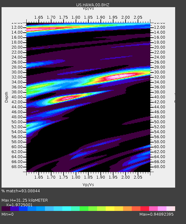
| Estimated Moho Depth: |
31.25 km |
| Estimated Crust Vp/Vs: |
1.97 |
| Assumed Crust Vp: |
6.419 km/s |
| Estimated Crust Vs: |
3.254 km/s |
| Estimated Crust Poisson's Ratio: |
0.33 |
|
| Radial Match: |
93.08844 % |
| Radial Bump: |
400 |
| Transverse Match: |
88.90814 % |
| Transverse Bump: |
400 |
| SOD ConfigId: |
558545 |
| Insert Time: |
2013-09-19 17:16:14.310 +0000 |
| GWidth: |
2.5 |
| Max Bumps: |
400 |
| Tol: |
0.001 |
|
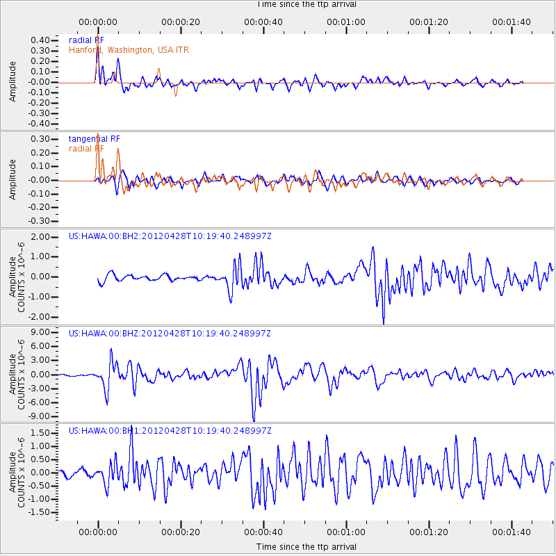
Signal To Noise
| Channel | StoN | STA | LTA |
| US:HAWA:00:BHZ:20120428T10:19:40.248997Z | 15.318402 | 2.8810537E-6 | 1.8807795E-7 |
| US:HAWA:00:BH1:20120428T10:19:40.248997Z | 2.8204608 | 3.8878895E-7 | 1.3784589E-7 |
| US:HAWA:00:BH2:20120428T10:19:40.248997Z | 4.0890536 | 6.055594E-7 | 1.4809281E-7 |
| Arrivals |
| Ps | 4.8 SECOND |
| PpPs | 14 SECOND |
| PsPs/PpSs | 19 SECOND |


