You are here: Home > Network List > US - United States National Seismic Network Stations List
> Station KSU1 Kansas State University--Konza Prairie, Kansas, USA > Earthquake Result Viewer
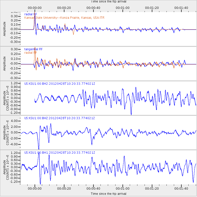
KSU1 Kansas State University--Konza Prairie, Kansas, USA - Earthquake Result Viewer
*The percent match for this event was below the threshold and hence no stack was calculated.
| Earthquake location: |
Tonga Islands |
| Earthquake latitude/longitude: |
-18.7/-174.7 |
| Earthquake time(UTC): |
2012/04/28 (119) 10:08:08 GMT |
| Earthquake Depth: |
135 km |
| Earthquake Magnitude: |
6.7 MW, 6.4 MB, 6.6 MW |
| Earthquake Catalog/Contributor: |
NEIC PDE/NEIC PDE-M |
|
| Network: |
US United States National Seismic Network |
| Station: |
KSU1 Kansas State University--Konza Prairie, Kansas, USA |
| Lat/Lon: |
39.10 N/96.61 W |
| Elevation: |
347 m |
|
| Distance: |
92.7 deg |
| Az: |
49.662 deg |
| Baz: |
248.221 deg |
| Ray Param: |
$rayparam |
*The percent match for this event was below the threshold and hence was not used in the summary stack. |
|
| Radial Match: |
76.87339 % |
| Radial Bump: |
400 |
| Transverse Match: |
74.48926 % |
| Transverse Bump: |
400 |
| SOD ConfigId: |
558545 |
| Insert Time: |
2013-09-19 17:16:26.175 +0000 |
| GWidth: |
2.5 |
| Max Bumps: |
400 |
| Tol: |
0.001 |
|
Signal To Noise
| Channel | StoN | STA | LTA |
| US:KSU1:00:BHZ:20120428T10:20:33.774021Z | 11.172676 | 2.1267376E-6 | 1.9035167E-7 |
| US:KSU1:00:BH1:20120428T10:20:33.774021Z | 3.7895205 | 6.492954E-7 | 1.713397E-7 |
| US:KSU1:00:BH2:20120428T10:20:33.774021Z | 2.0193408 | 3.5968554E-7 | 1.7812027E-7 |
| Arrivals |
| Ps | |
| PpPs | |
| PsPs/PpSs | |


