You are here: Home > Network List > US - United States National Seismic Network Stations List
> Station MSO Missoula, Montana, USA > Earthquake Result Viewer
MSO Missoula, Montana, USA - Earthquake Result Viewer
| Earthquake location: |
Tonga Islands |
| Earthquake latitude/longitude: |
-18.7/-174.7 |
| Earthquake time(UTC): |
2012/04/28 (119) 10:08:08 GMT |
| Earthquake Depth: |
135 km |
| Earthquake Magnitude: |
6.7 MW, 6.4 MB, 6.6 MW |
| Earthquake Catalog/Contributor: |
NEIC PDE/NEIC PDE-M |
|
| Network: |
US United States National Seismic Network |
| Station: |
MSO Missoula, Montana, USA |
| Lat/Lon: |
46.83 N/113.94 W |
| Elevation: |
1264 m |
|
| Distance: |
85.0 deg |
| Az: |
36.97 deg |
| Baz: |
236.129 deg |
| Ray Param: |
0.044743665 |
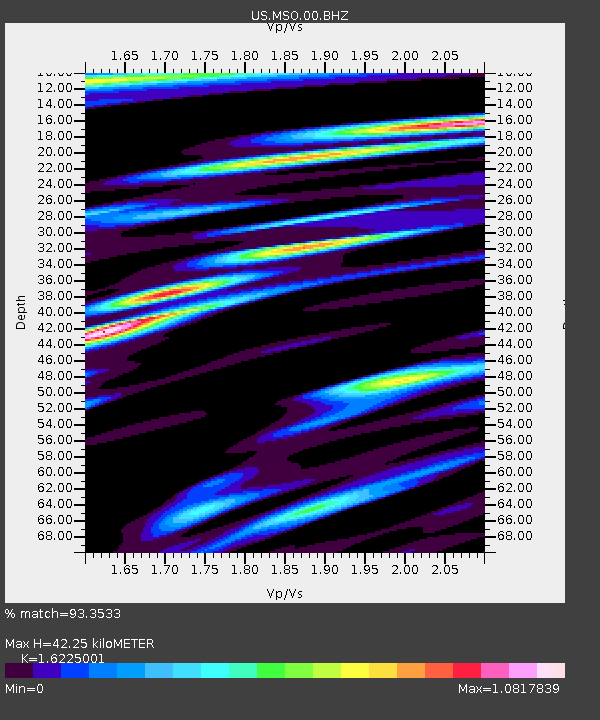
| Estimated Moho Depth: |
42.25 km |
| Estimated Crust Vp/Vs: |
1.62 |
| Assumed Crust Vp: |
6.353 km/s |
| Estimated Crust Vs: |
3.916 km/s |
| Estimated Crust Poisson's Ratio: |
0.19 |
|
| Radial Match: |
93.3533 % |
| Radial Bump: |
400 |
| Transverse Match: |
84.85183 % |
| Transverse Bump: |
400 |
| SOD ConfigId: |
558545 |
| Insert Time: |
2013-09-19 17:16:43.462 +0000 |
| GWidth: |
2.5 |
| Max Bumps: |
400 |
| Tol: |
0.001 |
|

Signal To Noise
| Channel | StoN | STA | LTA |
| US:MSO:00:BHZ:20120428T10:19:57.449985Z | 22.944313 | 2.2352117E-6 | 9.741899E-8 |
| US:MSO:00:BH1:20120428T10:19:57.449985Z | 5.605494 | 4.498107E-7 | 8.024461E-8 |
| US:MSO:00:BH2:20120428T10:19:57.449985Z | 5.699998 | 8.7395523E-7 | 1.5332553E-7 |
| Arrivals |
| Ps | 4.2 SECOND |
| PpPs | 17 SECOND |
| PsPs/PpSs | 21 SECOND |


