You are here: Home > Network List > US - United States National Seismic Network Stations List
> Station MVCO Mesa Verde, Colorado, USA > Earthquake Result Viewer
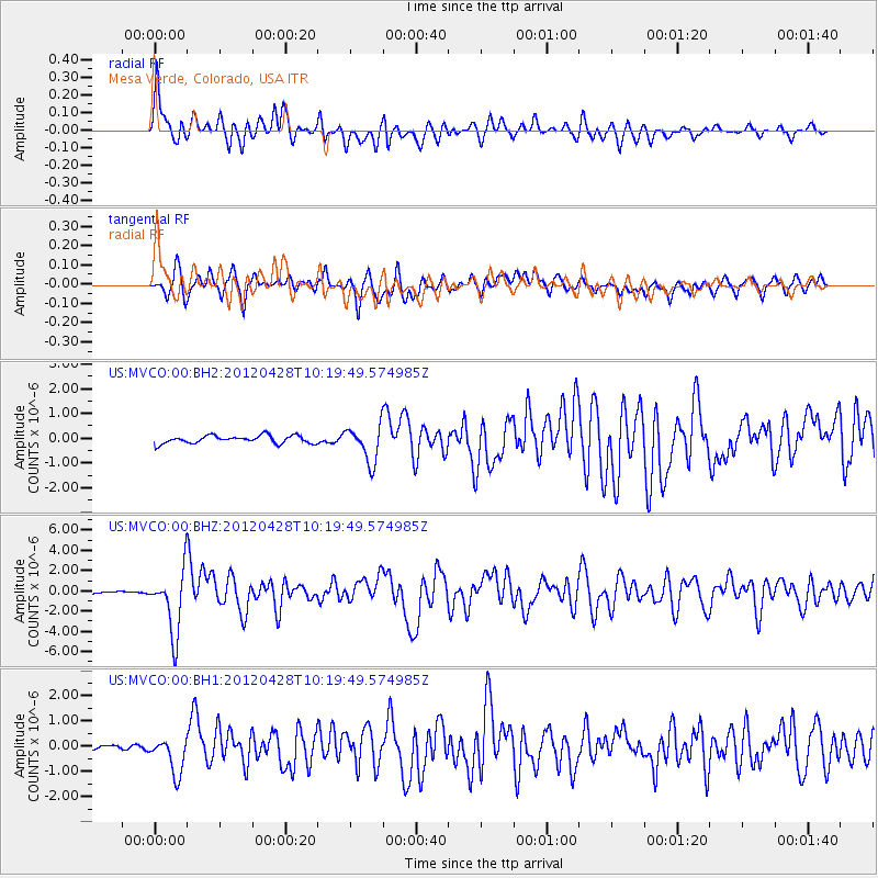
MVCO Mesa Verde, Colorado, USA - Earthquake Result Viewer
*The percent match for this event was below the threshold and hence no stack was calculated.
| Earthquake location: |
Tonga Islands |
| Earthquake latitude/longitude: |
-18.7/-174.7 |
| Earthquake time(UTC): |
2012/04/28 (119) 10:08:08 GMT |
| Earthquake Depth: |
135 km |
| Earthquake Magnitude: |
6.7 MW, 6.4 MB, 6.6 MW |
| Earthquake Catalog/Contributor: |
NEIC PDE/NEIC PDE-M |
|
| Network: |
US United States National Seismic Network |
| Station: |
MVCO Mesa Verde, Colorado, USA |
| Lat/Lon: |
37.21 N/108.50 W |
| Elevation: |
2170 m |
|
| Distance: |
83.5 deg |
| Az: |
47.33 deg |
| Baz: |
240.812 deg |
| Ray Param: |
$rayparam |
*The percent match for this event was below the threshold and hence was not used in the summary stack. |
|
| Radial Match: |
77.37861 % |
| Radial Bump: |
400 |
| Transverse Match: |
73.26036 % |
| Transverse Bump: |
400 |
| SOD ConfigId: |
558545 |
| Insert Time: |
2013-09-19 17:16:43.965 +0000 |
| GWidth: |
2.5 |
| Max Bumps: |
400 |
| Tol: |
0.001 |
|
Signal To Noise
| Channel | StoN | STA | LTA |
| US:MVCO:00:BHZ:20120428T10:19:49.574985Z | 30.5075 | 3.1236057E-6 | 1.0238813E-7 |
| US:MVCO:00:BH1:20120428T10:19:49.574985Z | 6.844059 | 7.209102E-7 | 1.0533372E-7 |
| US:MVCO:00:BH2:20120428T10:19:49.574985Z | 4.62951 | 7.3191694E-7 | 1.5809815E-7 |
| Arrivals |
| Ps | |
| PpPs | |
| PsPs/PpSs | |


