You are here: Home > Network List > US - United States National Seismic Network Stations List
> Station NATX Nacogdoches, Texas, USA > Earthquake Result Viewer
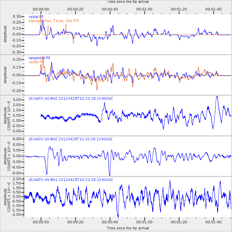
NATX Nacogdoches, Texas, USA - Earthquake Result Viewer
*The percent match for this event was below the threshold and hence no stack was calculated.
| Earthquake location: |
Tonga Islands |
| Earthquake latitude/longitude: |
-18.7/-174.7 |
| Earthquake time(UTC): |
2012/04/28 (119) 10:08:08 GMT |
| Earthquake Depth: |
135 km |
| Earthquake Magnitude: |
6.7 MW, 6.4 MB, 6.6 MW |
| Earthquake Catalog/Contributor: |
NEIC PDE/NEIC PDE-M |
|
| Network: |
US United States National Seismic Network |
| Station: |
NATX Nacogdoches, Texas, USA |
| Lat/Lon: |
31.76 N/94.66 W |
| Elevation: |
156 m |
|
| Distance: |
91.6 deg |
| Az: |
57.068 deg |
| Baz: |
249.069 deg |
| Ray Param: |
$rayparam |
*The percent match for this event was below the threshold and hence was not used in the summary stack. |
|
| Radial Match: |
71.66993 % |
| Radial Bump: |
400 |
| Transverse Match: |
79.75074 % |
| Transverse Bump: |
400 |
| SOD ConfigId: |
558545 |
| Insert Time: |
2013-09-19 17:16:48.745 +0000 |
| GWidth: |
2.5 |
| Max Bumps: |
400 |
| Tol: |
0.001 |
|
Signal To Noise
| Channel | StoN | STA | LTA |
| US:NATX:00:BHZ:20120428T10:20:28.324009Z | 22.061703 | 3.6778185E-6 | 1.6670602E-7 |
| US:NATX:00:BH1:20120428T10:20:28.324009Z | 1.310813 | 3.6718393E-7 | 2.8011922E-7 |
| US:NATX:00:BH2:20120428T10:20:28.324009Z | 1.6461941 | 5.13643E-7 | 3.1201847E-7 |
| Arrivals |
| Ps | |
| PpPs | |
| PsPs/PpSs | |


