You are here: Home > Network List > CN - Canadian National Seismograph Network Stations List
> Station PMB Pemberton, British Columbia, Canada > Earthquake Result Viewer
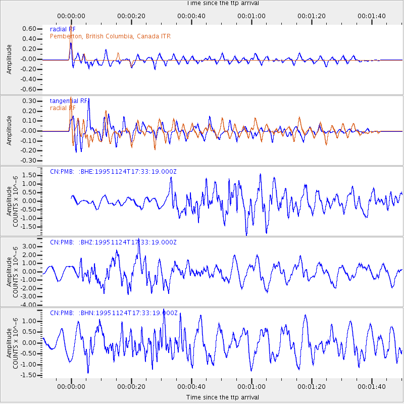
PMB Pemberton, British Columbia, Canada - Earthquake Result Viewer
*The percent match for this event was below the threshold and hence no stack was calculated.
| Earthquake location: |
Kuril Islands |
| Earthquake latitude/longitude: |
44.5/149.1 |
| Earthquake time(UTC): |
1995/11/24 (328) 17:24:12 GMT |
| Earthquake Depth: |
33 km |
| Earthquake Magnitude: |
6.1 MB, 6.3 MS, 6.1 UNKNOWN, 6.6 MW |
| Earthquake Catalog/Contributor: |
WHDF/NEIC |
|
| Network: |
CN Canadian National Seismograph Network |
| Station: |
PMB Pemberton, British Columbia, Canada |
| Lat/Lon: |
50.52 N/123.08 W |
| Elevation: |
400 m |
|
| Distance: |
56.3 deg |
| Az: |
50.091 deg |
| Baz: |
300.767 deg |
| Ray Param: |
$rayparam |
*The percent match for this event was below the threshold and hence was not used in the summary stack. |
|
| Radial Match: |
63.48049 % |
| Radial Bump: |
400 |
| Transverse Match: |
75.908806 % |
| Transverse Bump: |
400 |
| SOD ConfigId: |
4480 |
| Insert Time: |
2010-02-27 06:54:34.107 +0000 |
| GWidth: |
2.5 |
| Max Bumps: |
400 |
| Tol: |
0.001 |
|
Signal To Noise
| Channel | StoN | STA | LTA |
| CN:PMB: :BHZ:19951124T17:33:19.000Z | 2.5546992 | 7.1282017E-7 | 2.7902314E-7 |
| CN:PMB: :BHN:19951124T17:33:19.000Z | 2.7364836 | 6.085447E-7 | 2.22382E-7 |
| CN:PMB: :BHE:19951124T17:33:19.000Z | 2.8022187 | 5.5015465E-7 | 1.9632823E-7 |
| Arrivals |
| Ps | |
| PpPs | |
| PsPs/PpSs | |


