You are here: Home > Network List > US - United States National Seismic Network Stations List
> Station EGMT Eagleton, Montana, USA > Earthquake Result Viewer
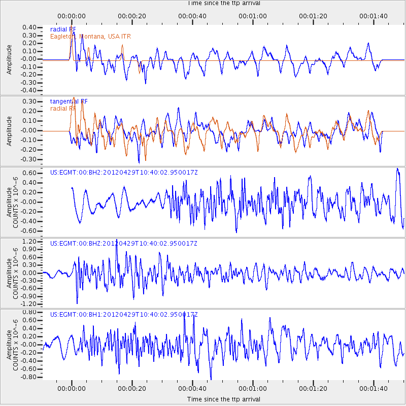
EGMT Eagleton, Montana, USA - Earthquake Result Viewer
*The percent match for this event was below the threshold and hence no stack was calculated.
| Earthquake location: |
Near East Coast Of Honshu, Japan |
| Earthquake latitude/longitude: |
35.6/140.3 |
| Earthquake time(UTC): |
2012/04/29 (120) 10:28:51 GMT |
| Earthquake Depth: |
44 km |
| Earthquake Magnitude: |
5.6 MB, 5.2 MS, 5.8 MW, 5.8 MW |
| Earthquake Catalog/Contributor: |
WHDF/NEIC |
|
| Network: |
US United States National Seismic Network |
| Station: |
EGMT Eagleton, Montana, USA |
| Lat/Lon: |
48.02 N/109.75 W |
| Elevation: |
1055 m |
|
| Distance: |
75.9 deg |
| Az: |
40.601 deg |
| Baz: |
307.807 deg |
| Ray Param: |
$rayparam |
*The percent match for this event was below the threshold and hence was not used in the summary stack. |
|
| Radial Match: |
64.11407 % |
| Radial Bump: |
400 |
| Transverse Match: |
58.927143 % |
| Transverse Bump: |
400 |
| SOD ConfigId: |
558545 |
| Insert Time: |
2013-09-19 17:25:50.558 +0000 |
| GWidth: |
2.5 |
| Max Bumps: |
400 |
| Tol: |
0.001 |
|
Signal To Noise
| Channel | StoN | STA | LTA |
| US:EGMT:00:BHZ:20120429T10:40:02.950017Z | 3.1810665 | 3.806951E-7 | 1.196753E-7 |
| US:EGMT:00:BH1:20120429T10:40:02.950017Z | 1.1633923 | 1.8788334E-7 | 1.6149613E-7 |
| US:EGMT:00:BH2:20120429T10:40:02.950017Z | 1.0124092 | 1.6897052E-7 | 1.6689943E-7 |
| Arrivals |
| Ps | |
| PpPs | |
| PsPs/PpSs | |


