You are here: Home > Network List > CN - Canadian National Seismograph Network Stations List
> Station PMB Pemberton, British Columbia, Canada > Earthquake Result Viewer
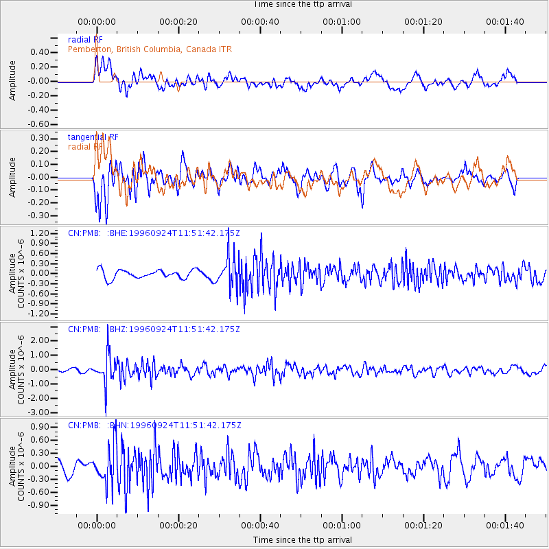
PMB Pemberton, British Columbia, Canada - Earthquake Result Viewer
*The percent match for this event was below the threshold and hence no stack was calculated.
| Earthquake location: |
Leeward Islands |
| Earthquake latitude/longitude: |
15.2/-61.4 |
| Earthquake time(UTC): |
1996/09/24 (268) 11:42:18 GMT |
| Earthquake Depth: |
147 km |
| Earthquake Magnitude: |
6.0 MB, 5.9 UNKNOWN, 5.7 MW |
| Earthquake Catalog/Contributor: |
WHDF/NEIC |
|
| Network: |
CN Canadian National Seismograph Network |
| Station: |
PMB Pemberton, British Columbia, Canada |
| Lat/Lon: |
50.52 N/123.08 W |
| Elevation: |
400 m |
|
| Distance: |
60.4 deg |
| Az: |
319.779 deg |
| Baz: |
102.404 deg |
| Ray Param: |
$rayparam |
*The percent match for this event was below the threshold and hence was not used in the summary stack. |
|
| Radial Match: |
75.681465 % |
| Radial Bump: |
400 |
| Transverse Match: |
63.415703 % |
| Transverse Bump: |
400 |
| SOD ConfigId: |
4480 |
| Insert Time: |
2010-02-27 06:54:48.203 +0000 |
| GWidth: |
2.5 |
| Max Bumps: |
400 |
| Tol: |
0.001 |
|
Signal To Noise
| Channel | StoN | STA | LTA |
| CN:PMB: :BHZ:19960924T11:51:42.175Z | 6.20143 | 1.0286564E-6 | 1.6587407E-7 |
| CN:PMB: :BHN:19960924T11:51:42.175Z | 1.9669096 | 4.4633924E-7 | 2.2692413E-7 |
| CN:PMB: :BHE:19960924T11:51:42.175Z | 3.592194 | 4.645177E-7 | 1.293131E-7 |
| Arrivals |
| Ps | |
| PpPs | |
| PsPs/PpSs | |


