You are here: Home > Network List > US - United States National Seismic Network Stations List
> Station AMTX Amarillo, Texas, USA > Earthquake Result Viewer
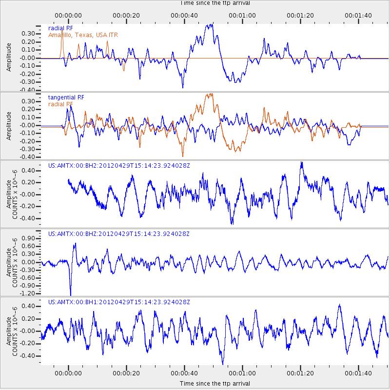
AMTX Amarillo, Texas, USA - Earthquake Result Viewer
*The percent match for this event was below the threshold and hence no stack was calculated.
| Earthquake location: |
Near East Coast Of Honshu, Japan |
| Earthquake latitude/longitude: |
39.7/142.0 |
| Earthquake time(UTC): |
2012/04/29 (120) 15:02:18 GMT |
| Earthquake Depth: |
10 km |
| Earthquake Magnitude: |
5.5 MW, 5.6 MW, 5.8 MB |
| Earthquake Catalog/Contributor: |
NEIC PDE/NEIC PDE-M |
|
| Network: |
US United States National Seismic Network |
| Station: |
AMTX Amarillo, Texas, USA |
| Lat/Lon: |
34.53 N/101.41 W |
| Elevation: |
1010 m |
|
| Distance: |
85.7 deg |
| Az: |
47.781 deg |
| Baz: |
316.243 deg |
| Ray Param: |
$rayparam |
*The percent match for this event was below the threshold and hence was not used in the summary stack. |
|
| Radial Match: |
43.026176 % |
| Radial Bump: |
400 |
| Transverse Match: |
63.68159 % |
| Transverse Bump: |
400 |
| SOD ConfigId: |
558545 |
| Insert Time: |
2013-09-19 17:29:25.814 +0000 |
| GWidth: |
2.5 |
| Max Bumps: |
400 |
| Tol: |
0.001 |
|
Signal To Noise
| Channel | StoN | STA | LTA |
| US:AMTX:00:BHZ:20120429T15:14:23.924028Z | 5.433164 | 4.339211E-7 | 7.9865266E-8 |
| US:AMTX:00:BH1:20120429T15:14:23.924028Z | 0.96059316 | 1.14701756E-7 | 1.1940722E-7 |
| US:AMTX:00:BH2:20120429T15:14:23.924028Z | 0.69751406 | 1.18605314E-7 | 1.7004004E-7 |
| Arrivals |
| Ps | |
| PpPs | |
| PsPs/PpSs | |


