You are here: Home > Network List > CN - Canadian National Seismograph Network Stations List
> Station PMB Pemberton, British Columbia, Canada > Earthquake Result Viewer
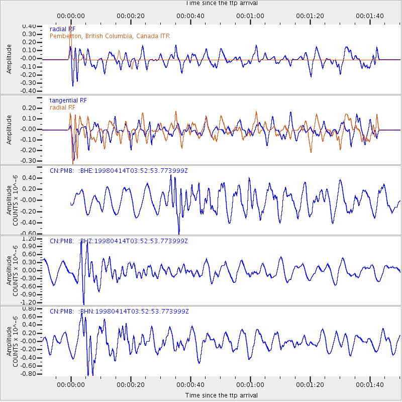
PMB Pemberton, British Columbia, Canada - Earthquake Result Viewer
*The percent match for this event was below the threshold and hence no stack was calculated.
| Earthquake location: |
South Of Fiji Islands |
| Earthquake latitude/longitude: |
-23.8/-179.9 |
| Earthquake time(UTC): |
1998/04/14 (104) 03:41:22 GMT |
| Earthquake Depth: |
499 km |
| Earthquake Magnitude: |
5.5 MB, 6.2 UNKNOWN, 6.1 MW |
| Earthquake Catalog/Contributor: |
WHDF/NEIC |
|
| Network: |
CN Canadian National Seismograph Network |
| Station: |
PMB Pemberton, British Columbia, Canada |
| Lat/Lon: |
50.52 N/123.08 W |
| Elevation: |
400 m |
|
| Distance: |
89.4 deg |
| Az: |
32.287 deg |
| Baz: |
230.024 deg |
| Ray Param: |
$rayparam |
*The percent match for this event was below the threshold and hence was not used in the summary stack. |
|
| Radial Match: |
71.579445 % |
| Radial Bump: |
400 |
| Transverse Match: |
51.363968 % |
| Transverse Bump: |
346 |
| SOD ConfigId: |
4480 |
| Insert Time: |
2010-02-27 06:54:57.663 +0000 |
| GWidth: |
2.5 |
| Max Bumps: |
400 |
| Tol: |
0.001 |
|
Signal To Noise
| Channel | StoN | STA | LTA |
| CN:PMB: :BHZ:19980414T03:52:53.773999Z | 2.0876863 | 4.889816E-7 | 2.3422176E-7 |
| CN:PMB: :BHN:19980414T03:52:53.773999Z | 1.9812868 | 3.6437592E-7 | 1.8390872E-7 |
| CN:PMB: :BHE:19980414T03:52:53.773999Z | 1.199821 | 1.9335495E-7 | 1.6115317E-7 |
| Arrivals |
| Ps | |
| PpPs | |
| PsPs/PpSs | |


