You are here: Home > Network List > US - United States National Seismic Network Stations List
> Station WRAK Wrangell Island, Southeastern Alaska, Alaska, USA > Earthquake Result Viewer
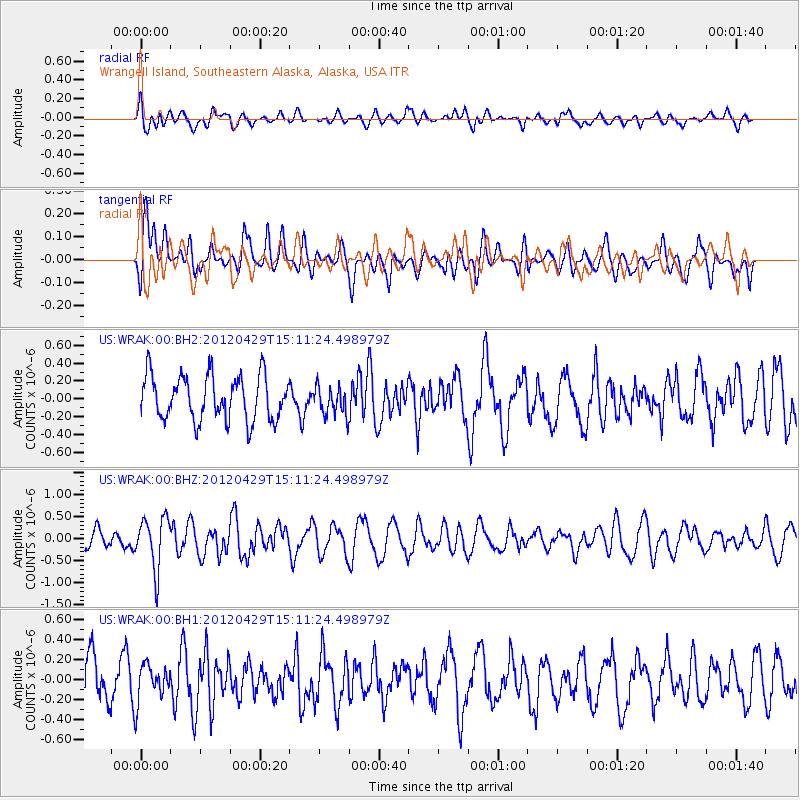
WRAK Wrangell Island, Southeastern Alaska, Alaska, USA - Earthquake Result Viewer
*The percent match for this event was below the threshold and hence no stack was calculated.
| Earthquake location: |
Near East Coast Of Honshu, Japan |
| Earthquake latitude/longitude: |
39.7/142.0 |
| Earthquake time(UTC): |
2012/04/29 (120) 15:02:18 GMT |
| Earthquake Depth: |
10 km |
| Earthquake Magnitude: |
5.5 MW, 5.6 MW, 5.8 MB |
| Earthquake Catalog/Contributor: |
NEIC PDE/NEIC PDE-M |
|
| Network: |
US United States National Seismic Network |
| Station: |
WRAK Wrangell Island, Southeastern Alaska, Alaska, USA |
| Lat/Lon: |
56.42 N/132.35 W |
| Elevation: |
81 m |
|
| Distance: |
55.8 deg |
| Az: |
42.065 deg |
| Baz: |
291.633 deg |
| Ray Param: |
$rayparam |
*The percent match for this event was below the threshold and hence was not used in the summary stack. |
|
| Radial Match: |
43.30969 % |
| Radial Bump: |
400 |
| Transverse Match: |
58.858967 % |
| Transverse Bump: |
400 |
| SOD ConfigId: |
558545 |
| Insert Time: |
2013-09-19 17:31:23.499 +0000 |
| GWidth: |
2.5 |
| Max Bumps: |
400 |
| Tol: |
0.001 |
|
Signal To Noise
| Channel | StoN | STA | LTA |
| US:WRAK:00:BHZ:20120429T15:11:24.498979Z | 2.5618134 | 5.8170826E-7 | 2.2706895E-7 |
| US:WRAK:00:BH1:20120429T15:11:24.498979Z | 1.0067521 | 1.7879897E-7 | 1.775998E-7 |
| US:WRAK:00:BH2:20120429T15:11:24.498979Z | 0.64977014 | 1.6253573E-7 | 2.5014344E-7 |
| Arrivals |
| Ps | |
| PpPs | |
| PsPs/PpSs | |


