You are here: Home > Network List > US - United States National Seismic Network Stations List
> Station AMTX Amarillo, Texas, USA > Earthquake Result Viewer
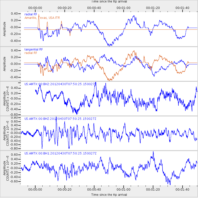
AMTX Amarillo, Texas, USA - Earthquake Result Viewer
*The percent match for this event was below the threshold and hence no stack was calculated.
| Earthquake location: |
Near Coast Of Central Chile |
| Earthquake latitude/longitude: |
-29.9/-71.5 |
| Earthquake time(UTC): |
2012/04/30 (121) 07:39:45 GMT |
| Earthquake Depth: |
37 km |
| Earthquake Magnitude: |
5.6 MW, 5.5 MW, 5.6 MB |
| Earthquake Catalog/Contributor: |
NEIC PDE/NEIC PDE-M |
|
| Network: |
US United States National Seismic Network |
| Station: |
AMTX Amarillo, Texas, USA |
| Lat/Lon: |
34.53 N/101.41 W |
| Elevation: |
1010 m |
|
| Distance: |
70.0 deg |
| Az: |
333.987 deg |
| Baz: |
152.521 deg |
| Ray Param: |
$rayparam |
*The percent match for this event was below the threshold and hence was not used in the summary stack. |
|
| Radial Match: |
31.544172 % |
| Radial Bump: |
400 |
| Transverse Match: |
54.19635 % |
| Transverse Bump: |
400 |
| SOD ConfigId: |
558545 |
| Insert Time: |
2013-09-19 17:34:12.898 +0000 |
| GWidth: |
2.5 |
| Max Bumps: |
400 |
| Tol: |
0.001 |
|
Signal To Noise
| Channel | StoN | STA | LTA |
| US:AMTX:00:BHZ:20120430T07:50:25.150027Z | 2.9711702 | 2.2837054E-7 | 7.686215E-8 |
| US:AMTX:00:BH1:20120430T07:50:25.150027Z | 2.0278676 | 3.1570332E-7 | 1.5568243E-7 |
| US:AMTX:00:BH2:20120430T07:50:25.150027Z | 2.956412 | 4.997167E-7 | 1.690281E-7 |
| Arrivals |
| Ps | |
| PpPs | |
| PsPs/PpSs | |


