You are here: Home > Network List > US - United States National Seismic Network Stations List
> Station HAWA Hanford, Washington, USA > Earthquake Result Viewer
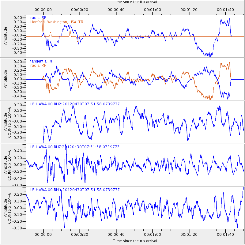
HAWA Hanford, Washington, USA - Earthquake Result Viewer
*The percent match for this event was below the threshold and hence no stack was calculated.
| Earthquake location: |
Near Coast Of Central Chile |
| Earthquake latitude/longitude: |
-29.9/-71.5 |
| Earthquake time(UTC): |
2012/04/30 (121) 07:39:45 GMT |
| Earthquake Depth: |
37 km |
| Earthquake Magnitude: |
5.6 MW, 5.5 MW, 5.6 MB |
| Earthquake Catalog/Contributor: |
NEIC PDE/NEIC PDE-M |
|
| Network: |
US United States National Seismic Network |
| Station: |
HAWA Hanford, Washington, USA |
| Lat/Lon: |
46.39 N/119.53 W |
| Elevation: |
364 m |
|
| Distance: |
87.5 deg |
| Az: |
328.973 deg |
| Baz: |
139.694 deg |
| Ray Param: |
$rayparam |
*The percent match for this event was below the threshold and hence was not used in the summary stack. |
|
| Radial Match: |
30.827816 % |
| Radial Bump: |
400 |
| Transverse Match: |
39.479237 % |
| Transverse Bump: |
400 |
| SOD ConfigId: |
558545 |
| Insert Time: |
2013-09-19 17:34:47.608 +0000 |
| GWidth: |
2.5 |
| Max Bumps: |
400 |
| Tol: |
0.001 |
|
Signal To Noise
| Channel | StoN | STA | LTA |
| US:HAWA:00:BHZ:20120430T07:51:58.073977Z | 2.8358893 | 2.408832E-7 | 8.494097E-8 |
| US:HAWA:00:BH1:20120430T07:51:58.073977Z | 0.95527196 | 1.0229646E-7 | 1.0708622E-7 |
| US:HAWA:00:BH2:20120430T07:51:58.073977Z | 0.734293 | 1.1133573E-7 | 1.5162304E-7 |
| Arrivals |
| Ps | |
| PpPs | |
| PsPs/PpSs | |


