You are here: Home > Network List > US - United States National Seismic Network Stations List
> Station WMOK Wichita Mountains, Oklahoma, USA > Earthquake Result Viewer
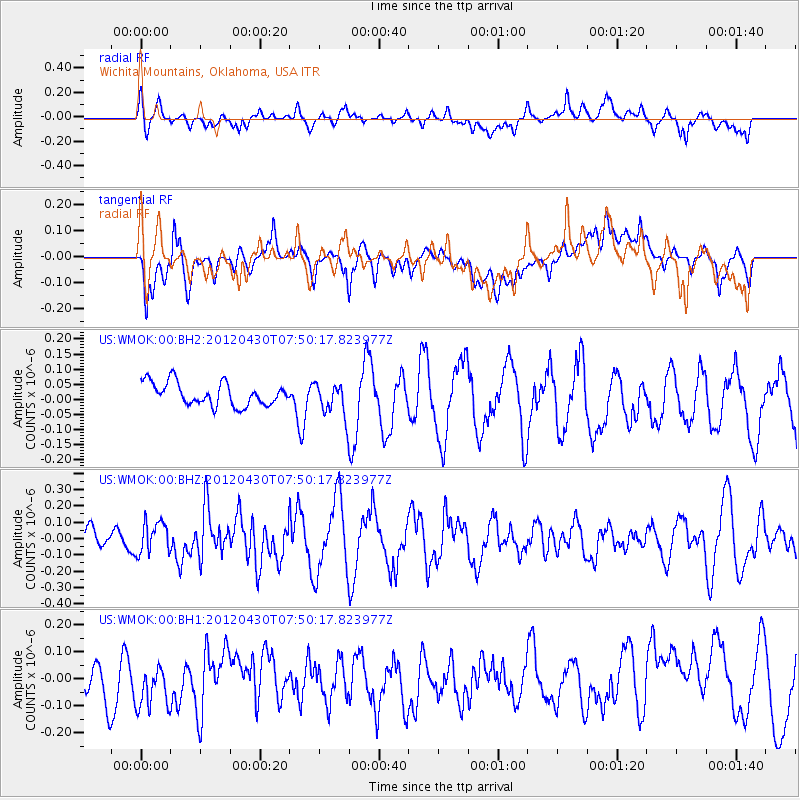
WMOK Wichita Mountains, Oklahoma, USA - Earthquake Result Viewer
*The percent match for this event was below the threshold and hence no stack was calculated.
| Earthquake location: |
Near Coast Of Central Chile |
| Earthquake latitude/longitude: |
-29.9/-71.5 |
| Earthquake time(UTC): |
2012/04/30 (121) 07:39:45 GMT |
| Earthquake Depth: |
37 km |
| Earthquake Magnitude: |
5.6 MW, 5.5 MW, 5.6 MB |
| Earthquake Catalog/Contributor: |
NEIC PDE/NEIC PDE-M |
|
| Network: |
US United States National Seismic Network |
| Station: |
WMOK Wichita Mountains, Oklahoma, USA |
| Lat/Lon: |
34.74 N/98.78 W |
| Elevation: |
486 m |
|
| Distance: |
69.2 deg |
| Az: |
336.156 deg |
| Baz: |
154.763 deg |
| Ray Param: |
$rayparam |
*The percent match for this event was below the threshold and hence was not used in the summary stack. |
|
| Radial Match: |
55.404316 % |
| Radial Bump: |
400 |
| Transverse Match: |
54.56508 % |
| Transverse Bump: |
400 |
| SOD ConfigId: |
558545 |
| Insert Time: |
2013-09-19 17:35:36.173 +0000 |
| GWidth: |
2.5 |
| Max Bumps: |
400 |
| Tol: |
0.001 |
|
Signal To Noise
| Channel | StoN | STA | LTA |
| US:WMOK:00:BHZ:20120430T07:50:17.823977Z | 0.8763434 | 9.70718E-8 | 1.1076913E-7 |
| US:WMOK:00:BH1:20120430T07:50:17.823977Z | 1.031515 | 1.0088586E-7 | 9.7803586E-8 |
| US:WMOK:00:BH2:20120430T07:50:17.823977Z | 1.475352 | 5.5555315E-8 | 3.7655635E-8 |
| Arrivals |
| Ps | |
| PpPs | |
| PsPs/PpSs | |


