You are here: Home > Network List > IU - Global Seismograph Network (GSN - IRIS/USGS) Stations List
> Station PMG Port Moresby, New Guinea > Earthquake Result Viewer
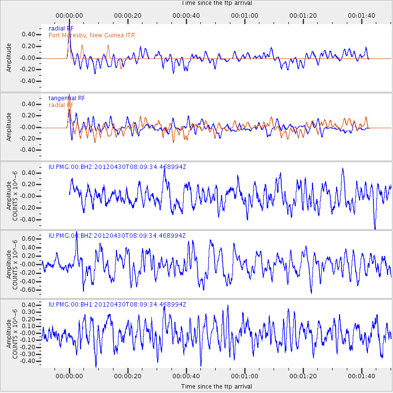
PMG Port Moresby, New Guinea - Earthquake Result Viewer
*The percent match for this event was below the threshold and hence no stack was calculated.
| Earthquake location: |
North Indian Ocean |
| Earthquake latitude/longitude: |
1.8/89.6 |
| Earthquake time(UTC): |
2012/04/30 (121) 08:00:10 GMT |
| Earthquake Depth: |
10 km |
| Earthquake Magnitude: |
5.7 MW, 5.5 MB, 5.6 MS, 5.7 MW |
| Earthquake Catalog/Contributor: |
NEIC PDE/NEIC PDE-M |
|
| Network: |
IU Global Seismograph Network (GSN - IRIS/USGS) |
| Station: |
PMG Port Moresby, New Guinea |
| Lat/Lon: |
9.40 S/147.16 E |
| Elevation: |
90 m |
|
| Distance: |
58.4 deg |
| Az: |
102.09 deg |
| Baz: |
277.902 deg |
| Ray Param: |
$rayparam |
*The percent match for this event was below the threshold and hence was not used in the summary stack. |
|
| Radial Match: |
55.583744 % |
| Radial Bump: |
400 |
| Transverse Match: |
54.750397 % |
| Transverse Bump: |
400 |
| SOD ConfigId: |
558545 |
| Insert Time: |
2013-09-19 17:37:01.413 +0000 |
| GWidth: |
2.5 |
| Max Bumps: |
400 |
| Tol: |
0.001 |
|
Signal To Noise
| Channel | StoN | STA | LTA |
| IU:PMG:00:BHZ:20120430T08:09:34.468994Z | 2.2327752 | 2.642354E-7 | 1.1834394E-7 |
| IU:PMG:00:BH1:20120430T08:09:34.468994Z | 1.1457194 | 1.3267558E-7 | 1.1580111E-7 |
| IU:PMG:00:BH2:20120430T08:09:34.468994Z | 1.7095515 | 2.0060345E-7 | 1.1734274E-7 |
| Arrivals |
| Ps | |
| PpPs | |
| PsPs/PpSs | |


