You are here: Home > Network List > US - United States National Seismic Network Stations List
> Station DGMT Dagmar, Montana, USA > Earthquake Result Viewer
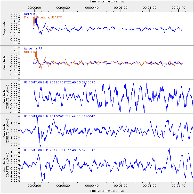
DGMT Dagmar, Montana, USA - Earthquake Result Viewer
*The percent match for this event was below the threshold and hence no stack was calculated.
| Earthquake location: |
Near Coast Of Chiapas, Mexico |
| Earthquake latitude/longitude: |
14.4/-92.9 |
| Earthquake time(UTC): |
2012/05/01 (122) 22:43:33 GMT |
| Earthquake Depth: |
14 km |
| Earthquake Magnitude: |
5.6 MB, 5.8 MS, 6.0 MW, 5.9 MW |
| Earthquake Catalog/Contributor: |
WHDF/NEIC |
|
| Network: |
US United States National Seismic Network |
| Station: |
DGMT Dagmar, Montana, USA |
| Lat/Lon: |
48.47 N/104.20 W |
| Elevation: |
0.0 m |
|
| Distance: |
35.3 deg |
| Az: |
346.946 deg |
| Baz: |
160.797 deg |
| Ray Param: |
$rayparam |
*The percent match for this event was below the threshold and hence was not used in the summary stack. |
|
| Radial Match: |
79.050156 % |
| Radial Bump: |
365 |
| Transverse Match: |
34.521378 % |
| Transverse Bump: |
396 |
| SOD ConfigId: |
558545 |
| Insert Time: |
2013-09-19 17:45:07.878 +0000 |
| GWidth: |
2.5 |
| Max Bumps: |
400 |
| Tol: |
0.001 |
|
Signal To Noise
| Channel | StoN | STA | LTA |
| US:DGMT:00:BHZ:20120501T22:49:56.625004Z | 6.350405 | 1.2757441E-6 | 2.0089176E-7 |
| US:DGMT:00:BH1:20120501T22:49:56.625004Z | 2.731416 | 5.922779E-7 | 2.1683914E-7 |
| US:DGMT:00:BH2:20120501T22:49:56.625004Z | 0.98210084 | 2.2803012E-7 | 2.3218605E-7 |
| Arrivals |
| Ps | |
| PpPs | |
| PsPs/PpSs | |


