You are here: Home > Network List > IU - Global Seismograph Network (GSN - IRIS/USGS) Stations List
> Station PMG Port Moresby, New Guinea > Earthquake Result Viewer
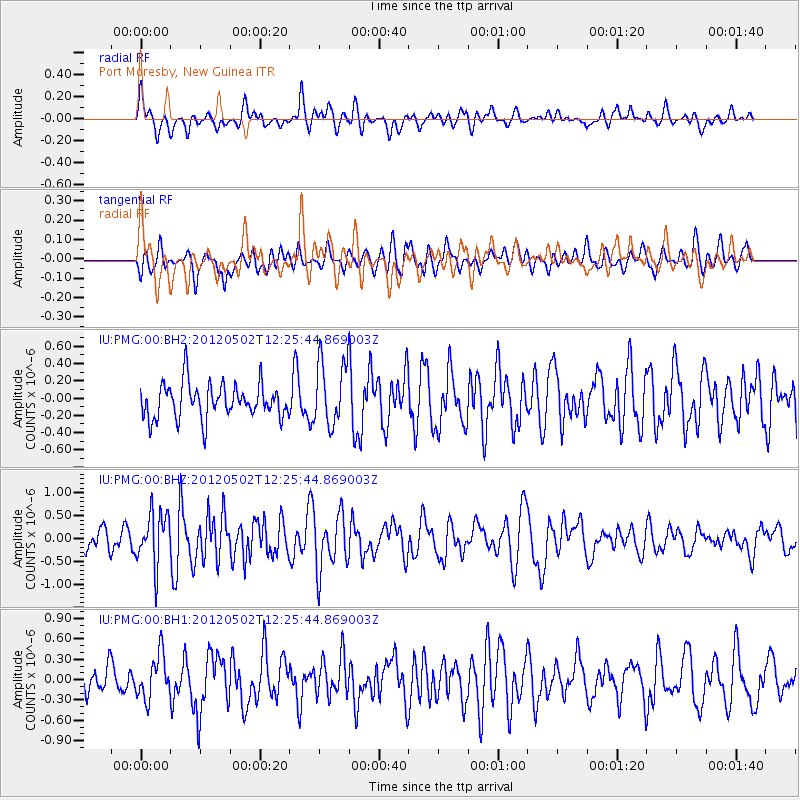
PMG Port Moresby, New Guinea - Earthquake Result Viewer
*The percent match for this event was below the threshold and hence no stack was calculated.
| Earthquake location: |
West Of Macquarie Island |
| Earthquake latitude/longitude: |
-54.6/143.8 |
| Earthquake time(UTC): |
2012/05/02 (123) 12:17:59 GMT |
| Earthquake Depth: |
10 km |
| Earthquake Magnitude: |
5.5 MB, 5.5 MS, 5.8 MW, 5.7 MW |
| Earthquake Catalog/Contributor: |
WHDF/NEIC |
|
| Network: |
IU Global Seismograph Network (GSN - IRIS/USGS) |
| Station: |
PMG Port Moresby, New Guinea |
| Lat/Lon: |
9.40 S/147.16 E |
| Elevation: |
90 m |
|
| Distance: |
45.1 deg |
| Az: |
4.631 deg |
| Baz: |
182.731 deg |
| Ray Param: |
$rayparam |
*The percent match for this event was below the threshold and hence was not used in the summary stack. |
|
| Radial Match: |
64.498604 % |
| Radial Bump: |
400 |
| Transverse Match: |
42.5862 % |
| Transverse Bump: |
400 |
| SOD ConfigId: |
558545 |
| Insert Time: |
2013-09-19 17:47:37.784 +0000 |
| GWidth: |
2.5 |
| Max Bumps: |
400 |
| Tol: |
0.001 |
|
Signal To Noise
| Channel | StoN | STA | LTA |
| IU:PMG:00:BHZ:20120502T12:25:44.869003Z | 2.6108367 | 5.6877934E-7 | 2.1785328E-7 |
| IU:PMG:00:BH1:20120502T12:25:44.869003Z | 1.4253972 | 3.1998644E-7 | 2.2448933E-7 |
| IU:PMG:00:BH2:20120502T12:25:44.869003Z | 1.8830435 | 3.7811498E-7 | 2.0079992E-7 |
| Arrivals |
| Ps | |
| PpPs | |
| PsPs/PpSs | |


