You are here: Home > Network List > IU - Global Seismograph Network (GSN - IRIS/USGS) Stations List
> Station POHA Pohakuloa, Hawaii, USA > Earthquake Result Viewer
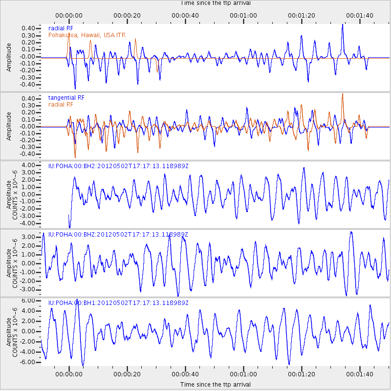
POHA Pohakuloa, Hawaii, USA - Earthquake Result Viewer
*The percent match for this event was below the threshold and hence no stack was calculated.
| Earthquake location: |
Southeast Of Easter Island |
| Earthquake latitude/longitude: |
-35.9/-102.7 |
| Earthquake time(UTC): |
2012/05/02 (123) 17:06:05 GMT |
| Earthquake Depth: |
10 km |
| Earthquake Magnitude: |
5.5 MW, 4.9 MS, 4.7 MB |
| Earthquake Catalog/Contributor: |
WHDF/NEIC |
|
| Network: |
IU Global Seismograph Network (GSN - IRIS/USGS) |
| Station: |
POHA Pohakuloa, Hawaii, USA |
| Lat/Lon: |
19.76 N/155.53 W |
| Elevation: |
1990 m |
|
| Distance: |
74.6 deg |
| Az: |
308.889 deg |
| Baz: |
137.847 deg |
| Ray Param: |
$rayparam |
*The percent match for this event was below the threshold and hence was not used in the summary stack. |
|
| Radial Match: |
58.530167 % |
| Radial Bump: |
329 |
| Transverse Match: |
58.12139 % |
| Transverse Bump: |
394 |
| SOD ConfigId: |
558545 |
| Insert Time: |
2013-09-19 17:50:14.598 +0000 |
| GWidth: |
2.5 |
| Max Bumps: |
400 |
| Tol: |
0.001 |
|
Signal To Noise
| Channel | StoN | STA | LTA |
| IU:POHA:00:BHZ:20120502T17:17:13.118989Z | 0.73382485 | 1.2549095E-6 | 1.7100941E-6 |
| IU:POHA:00:BH1:20120502T17:17:13.118989Z | 1.3740067 | 3.8748076E-6 | 2.8200789E-6 |
| IU:POHA:00:BH2:20120502T17:17:13.118989Z | 1.2188916 | 1.4673575E-6 | 1.2038457E-6 |
| Arrivals |
| Ps | |
| PpPs | |
| PsPs/PpSs | |


