You are here: Home > Network List > CN - Canadian National Seismograph Network Stations List
> Station PMB Pemberton, British Columbia, Canada > Earthquake Result Viewer
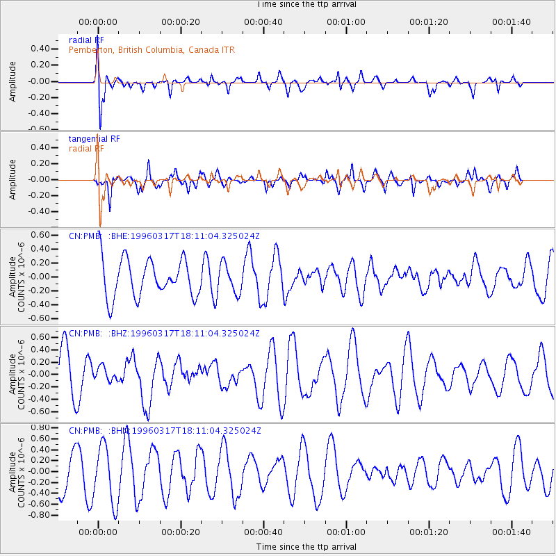
PMB Pemberton, British Columbia, Canada - Earthquake Result Viewer
*The percent match for this event was below the threshold and hence no stack was calculated.
| Earthquake location: |
Eastern New Guinea Reg., P.N.G. |
| Earthquake latitude/longitude: |
-6.3/147.9 |
| Earthquake time(UTC): |
1996/03/17 (077) 17:58:20 GMT |
| Earthquake Depth: |
33 km |
| Earthquake Magnitude: |
5.5 MB, 6.0 MS, 6.1 UNKNOWN, 6.2 ML |
| Earthquake Catalog/Contributor: |
WHDF/NEIC |
|
| Network: |
CN Canadian National Seismograph Network |
| Station: |
PMB Pemberton, British Columbia, Canada |
| Lat/Lon: |
50.52 N/123.08 W |
| Elevation: |
400 m |
|
| Distance: |
94.2 deg |
| Az: |
39.789 deg |
| Baz: |
265.264 deg |
| Ray Param: |
$rayparam |
*The percent match for this event was below the threshold and hence was not used in the summary stack. |
|
| Radial Match: |
63.593945 % |
| Radial Bump: |
400 |
| Transverse Match: |
63.935116 % |
| Transverse Bump: |
382 |
| SOD ConfigId: |
4480 |
| Insert Time: |
2010-02-27 06:56:00.433 +0000 |
| GWidth: |
2.5 |
| Max Bumps: |
400 |
| Tol: |
0.001 |
|
Signal To Noise
| Channel | StoN | STA | LTA |
| CN:PMB: :BHZ:19960317T18:11:04.325024Z | 0.25148693 | 1.11219585E-7 | 4.4224802E-7 |
| CN:PMB: :BHN:19960317T18:11:04.325024Z | 1.3978287 | 5.3313977E-7 | 3.814057E-7 |
| CN:PMB: :BHE:19960317T18:11:04.325024Z | 0.7423853 | 2.0533672E-7 | 2.7659047E-7 |
| Arrivals |
| Ps | |
| PpPs | |
| PsPs/PpSs | |


