You are here: Home > Network List > US - United States National Seismic Network Stations List
> Station AGMN Agassiz National Wildlife Refuge, Minnesota, USA > Earthquake Result Viewer
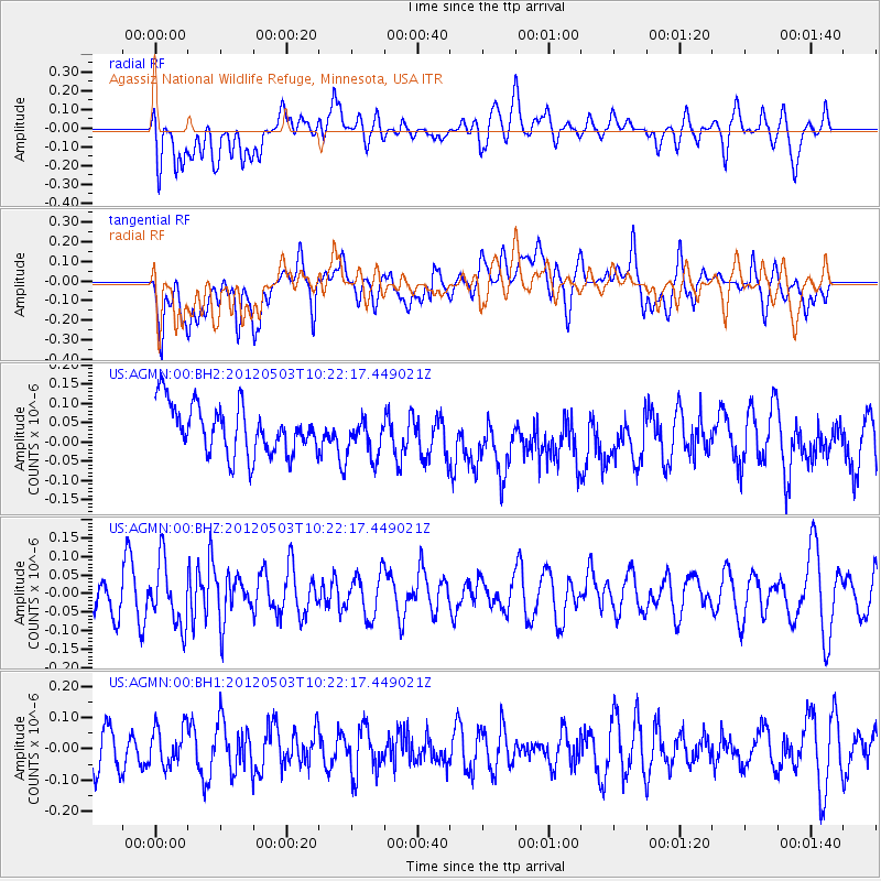
AGMN Agassiz National Wildlife Refuge, Minnesota, USA - Earthquake Result Viewer
*The percent match for this event was below the threshold and hence no stack was calculated.
| Earthquake location: |
Iran-Iraq Border Region |
| Earthquake latitude/longitude: |
32.7/47.7 |
| Earthquake time(UTC): |
2012/05/03 (124) 10:09:35 GMT |
| Earthquake Depth: |
10 km |
| Earthquake Magnitude: |
5.6 MB, 5.2 MW, 5.4 MW |
| Earthquake Catalog/Contributor: |
WHDF/NEIC |
|
| Network: |
US United States National Seismic Network |
| Station: |
AGMN Agassiz National Wildlife Refuge, Minnesota, USA |
| Lat/Lon: |
48.30 N/95.86 W |
| Elevation: |
351 m |
|
| Distance: |
93.0 deg |
| Az: |
336.615 deg |
| Baz: |
30.06 deg |
| Ray Param: |
$rayparam |
*The percent match for this event was below the threshold and hence was not used in the summary stack. |
|
| Radial Match: |
34.962593 % |
| Radial Bump: |
400 |
| Transverse Match: |
51.89659 % |
| Transverse Bump: |
400 |
| SOD ConfigId: |
558545 |
| Insert Time: |
2013-09-19 17:56:32.034 +0000 |
| GWidth: |
2.5 |
| Max Bumps: |
400 |
| Tol: |
0.001 |
|
Signal To Noise
| Channel | StoN | STA | LTA |
| US:AGMN:00:BHZ:20120503T10:22:17.449021Z | 1.3035634 | 8.4676515E-8 | 6.495773E-8 |
| US:AGMN:00:BH1:20120503T10:22:17.449021Z | 0.93351626 | 6.1936824E-8 | 6.634788E-8 |
| US:AGMN:00:BH2:20120503T10:22:17.449021Z | 0.8465224 | 5.392236E-8 | 6.3698685E-8 |
| Arrivals |
| Ps | |
| PpPs | |
| PsPs/PpSs | |


