You are here: Home > Network List > CN - Canadian National Seismograph Network Stations List
> Station PMB Pemberton, British Columbia, Canada > Earthquake Result Viewer
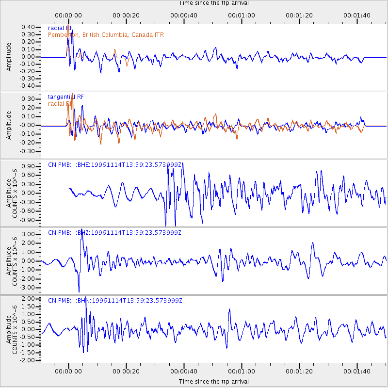
PMB Pemberton, British Columbia, Canada - Earthquake Result Viewer
*The percent match for this event was below the threshold and hence no stack was calculated.
| Earthquake location: |
Fiji Islands Region |
| Earthquake latitude/longitude: |
-21.2/-176.6 |
| Earthquake time(UTC): |
1996/11/14 (319) 13:47:38 GMT |
| Earthquake Depth: |
192 km |
| Earthquake Magnitude: |
5.9 MB, 6.2 UNKNOWN, 6.1 MW |
| Earthquake Catalog/Contributor: |
WHDF/NEIC |
|
| Network: |
CN Canadian National Seismograph Network |
| Station: |
PMB Pemberton, British Columbia, Canada |
| Lat/Lon: |
50.52 N/123.08 W |
| Elevation: |
400 m |
|
| Distance: |
85.6 deg |
| Az: |
30.995 deg |
| Baz: |
228.813 deg |
| Ray Param: |
$rayparam |
*The percent match for this event was below the threshold and hence was not used in the summary stack. |
|
| Radial Match: |
72.06117 % |
| Radial Bump: |
400 |
| Transverse Match: |
59.83923 % |
| Transverse Bump: |
400 |
| SOD ConfigId: |
4480 |
| Insert Time: |
2010-02-27 06:56:03.341 +0000 |
| GWidth: |
2.5 |
| Max Bumps: |
400 |
| Tol: |
0.001 |
|
Signal To Noise
| Channel | StoN | STA | LTA |
| CN:PMB: :BHZ:19961114T13:59:23.573999Z | 5.8662415 | 1.5022204E-6 | 2.5607883E-7 |
| CN:PMB: :BHN:19961114T13:59:23.573999Z | 1.8800151 | 3.5395084E-7 | 1.882702E-7 |
| CN:PMB: :BHE:19961114T13:59:23.573999Z | 2.4210887 | 3.8770966E-7 | 1.6013855E-7 |
| Arrivals |
| Ps | |
| PpPs | |
| PsPs/PpSs | |


