You are here: Home > Network List > CN - Canadian National Seismograph Network Stations List
> Station PMB Pemberton, British Columbia, Canada > Earthquake Result Viewer
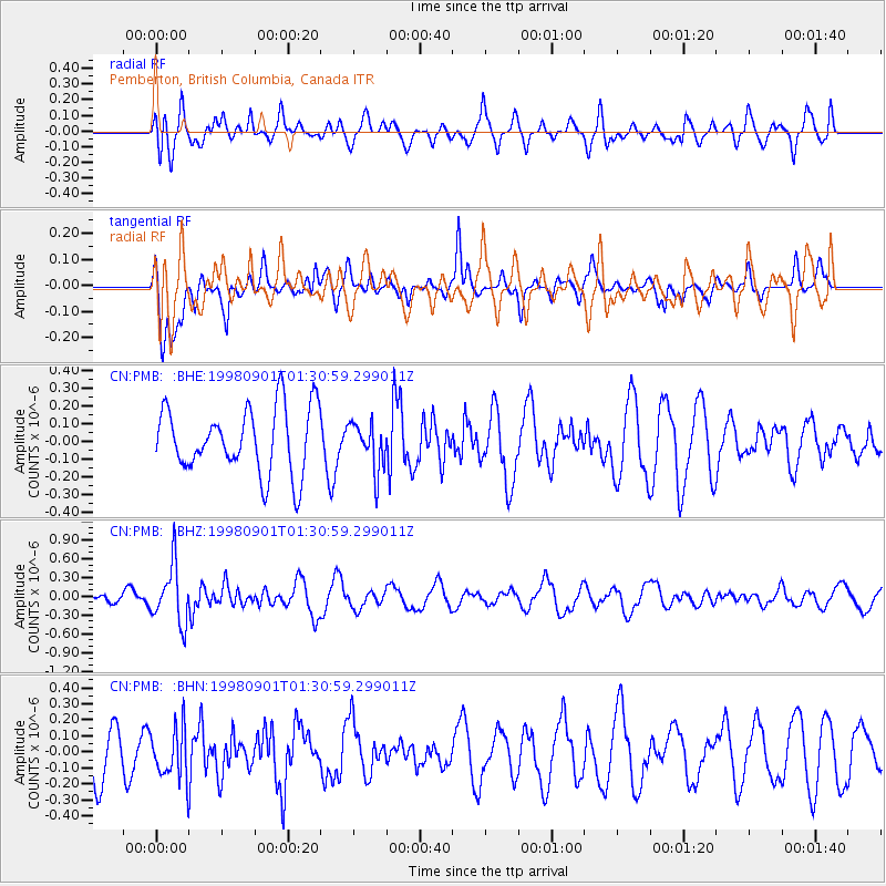
PMB Pemberton, British Columbia, Canada - Earthquake Result Viewer
*The percent match for this event was below the threshold and hence no stack was calculated.
| Earthquake location: |
Tonga Islands |
| Earthquake latitude/longitude: |
-17.6/-174.8 |
| Earthquake time(UTC): |
1998/09/01 (244) 01:19:37 GMT |
| Earthquake Depth: |
220 km |
| Earthquake Magnitude: |
5.6 UNKNOWN, 5.3 MB, 5.6 MW |
| Earthquake Catalog/Contributor: |
WHDF/NEIC |
|
| Network: |
CN Canadian National Seismograph Network |
| Station: |
PMB Pemberton, British Columbia, Canada |
| Lat/Lon: |
50.52 N/123.08 W |
| Elevation: |
400 m |
|
| Distance: |
81.6 deg |
| Az: |
30.426 deg |
| Baz: |
229.184 deg |
| Ray Param: |
$rayparam |
*The percent match for this event was below the threshold and hence was not used in the summary stack. |
|
| Radial Match: |
51.524387 % |
| Radial Bump: |
400 |
| Transverse Match: |
70.70036 % |
| Transverse Bump: |
400 |
| SOD ConfigId: |
4480 |
| Insert Time: |
2010-02-27 06:56:10.969 +0000 |
| GWidth: |
2.5 |
| Max Bumps: |
400 |
| Tol: |
0.001 |
|
Signal To Noise
| Channel | StoN | STA | LTA |
| CN:PMB: :BHZ:19980901T01:30:59.299011Z | 3.3368123 | 4.5975204E-7 | 1.3778181E-7 |
| CN:PMB: :BHN:19980901T01:30:59.299011Z | 0.88339853 | 1.5752326E-7 | 1.7831506E-7 |
| CN:PMB: :BHE:19980901T01:30:59.299011Z | 0.7229251 | 1.333353E-7 | 1.8443862E-7 |
| Arrivals |
| Ps | |
| PpPs | |
| PsPs/PpSs | |


