You are here: Home > Network List > IU - Global Seismograph Network (GSN - IRIS/USGS) Stations List
> Station RSSD Black Hills, South Dakota, USA > Earthquake Result Viewer
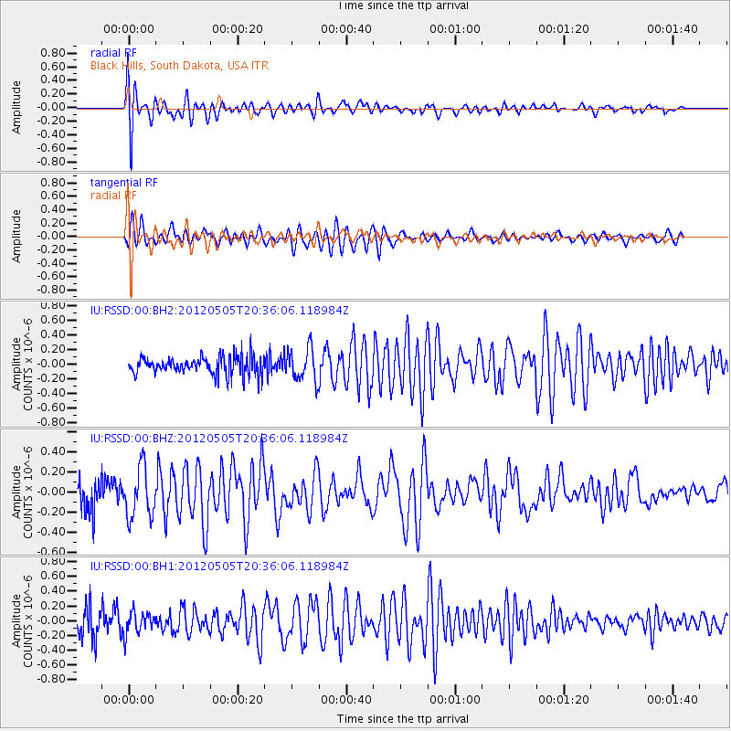
RSSD Black Hills, South Dakota, USA - Earthquake Result Viewer
*The percent match for this event was below the threshold and hence no stack was calculated.
| Earthquake location: |
Tonga Islands |
| Earthquake latitude/longitude: |
-21.5/-174.2 |
| Earthquake time(UTC): |
2012/05/05 (126) 20:23:31 GMT |
| Earthquake Depth: |
8.5 km |
| Earthquake Magnitude: |
5.6 MS, 5.7 MW, 5.6 MW |
| Earthquake Catalog/Contributor: |
WHDF/NEIC |
|
| Network: |
IU Global Seismograph Network (GSN - IRIS/USGS) |
| Station: |
RSSD Black Hills, South Dakota, USA |
| Lat/Lon: |
44.12 N/104.04 W |
| Elevation: |
2090 m |
|
| Distance: |
91.4 deg |
| Az: |
42.672 deg |
| Baz: |
241.231 deg |
| Ray Param: |
$rayparam |
*The percent match for this event was below the threshold and hence was not used in the summary stack. |
|
| Radial Match: |
68.24859 % |
| Radial Bump: |
400 |
| Transverse Match: |
52.902348 % |
| Transverse Bump: |
400 |
| SOD ConfigId: |
558545 |
| Insert Time: |
2013-09-19 18:00:02.216 +0000 |
| GWidth: |
2.5 |
| Max Bumps: |
400 |
| Tol: |
0.001 |
|
Signal To Noise
| Channel | StoN | STA | LTA |
| IU:RSSD:00:BHZ:20120505T20:36:06.118984Z | 2.1856651 | 2.5341544E-7 | 1.1594431E-7 |
| IU:RSSD:00:BH1:20120505T20:36:06.118984Z | 0.9522948 | 1.5211975E-7 | 1.597402E-7 |
| IU:RSSD:00:BH2:20120505T20:36:06.118984Z | 1.861804 | 2.2482232E-7 | 1.207551E-7 |
| Arrivals |
| Ps | |
| PpPs | |
| PsPs/PpSs | |


