You are here: Home > Network List > IU - Global Seismograph Network (GSN - IRIS/USGS) Stations List
> Station RSSD Black Hills, South Dakota, USA > Earthquake Result Viewer
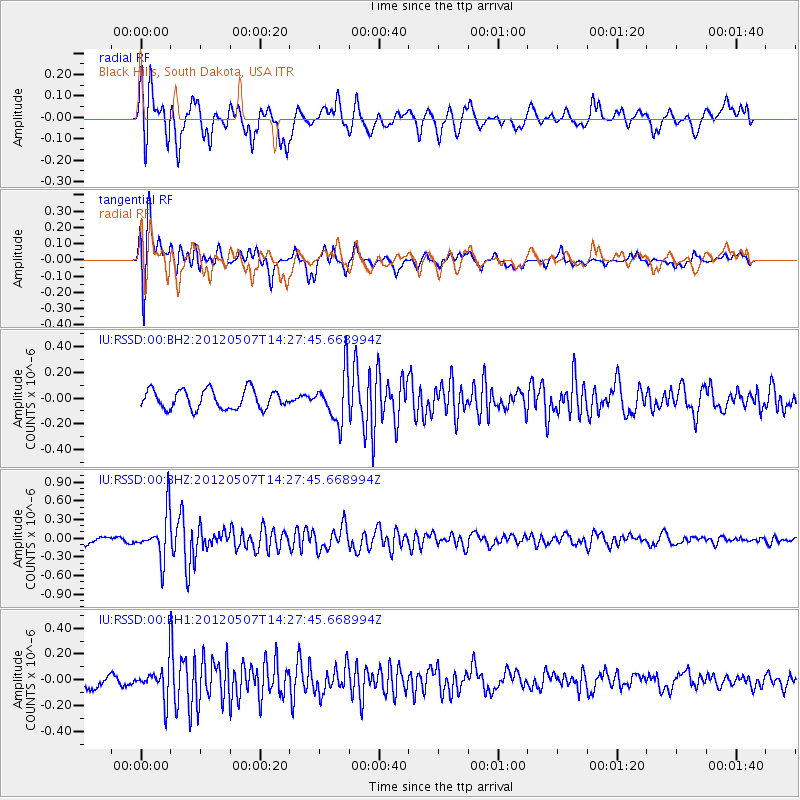
RSSD Black Hills, South Dakota, USA - Earthquake Result Viewer
*The percent match for this event was below the threshold and hence no stack was calculated.
| Earthquake location: |
Eastern Caucasus |
| Earthquake latitude/longitude: |
41.6/46.7 |
| Earthquake time(UTC): |
2012/05/07 (128) 14:15:14 GMT |
| Earthquake Depth: |
12 km |
| Earthquake Magnitude: |
5.6 MB, 5.0 MS, 5.3 MW, 5.4 MW |
| Earthquake Catalog/Contributor: |
WHDF/NEIC |
|
| Network: |
IU Global Seismograph Network (GSN - IRIS/USGS) |
| Station: |
RSSD Black Hills, South Dakota, USA |
| Lat/Lon: |
44.12 N/104.04 W |
| Elevation: |
2090 m |
|
| Distance: |
90.8 deg |
| Az: |
339.397 deg |
| Baz: |
21.513 deg |
| Ray Param: |
$rayparam |
*The percent match for this event was below the threshold and hence was not used in the summary stack. |
|
| Radial Match: |
66.47662 % |
| Radial Bump: |
400 |
| Transverse Match: |
85.346504 % |
| Transverse Bump: |
400 |
| SOD ConfigId: |
558545 |
| Insert Time: |
2013-09-19 18:12:08.048 +0000 |
| GWidth: |
2.5 |
| Max Bumps: |
400 |
| Tol: |
0.001 |
|
Signal To Noise
| Channel | StoN | STA | LTA |
| IU:RSSD:00:BHZ:20120507T14:27:45.668994Z | 3.303403 | 3.7171122E-7 | 1.1252373E-7 |
| IU:RSSD:00:BH1:20120507T14:27:45.668994Z | 2.4686432 | 1.3293963E-7 | 5.3851295E-8 |
| IU:RSSD:00:BH2:20120507T14:27:45.668994Z | 2.5541883 | 1.8895298E-7 | 7.39777E-8 |
| Arrivals |
| Ps | |
| PpPs | |
| PsPs/PpSs | |


