You are here: Home > Network List > US - United States National Seismic Network Stations List
> Station MSO Missoula, Montana, USA > Earthquake Result Viewer
MSO Missoula, Montana, USA - Earthquake Result Viewer
*The percent match for this event was below the threshold and hence no stack was calculated.
| Earthquake location: |
Eastern Caucasus |
| Earthquake latitude/longitude: |
41.6/46.7 |
| Earthquake time(UTC): |
2012/05/07 (128) 14:15:14 GMT |
| Earthquake Depth: |
12 km |
| Earthquake Magnitude: |
5.6 MB, 5.0 MS, 5.3 MW, 5.4 MW |
| Earthquake Catalog/Contributor: |
WHDF/NEIC |
|
| Network: |
US United States National Seismic Network |
| Station: |
MSO Missoula, Montana, USA |
| Lat/Lon: |
46.83 N/113.94 W |
| Elevation: |
1264 m |
|
| Distance: |
90.3 deg |
| Az: |
346.856 deg |
| Baz: |
14.393 deg |
| Ray Param: |
$rayparam |
*The percent match for this event was below the threshold and hence was not used in the summary stack. |
|
| Radial Match: |
59.84615 % |
| Radial Bump: |
365 |
| Transverse Match: |
42.06002 % |
| Transverse Bump: |
400 |
| SOD ConfigId: |
558545 |
| Insert Time: |
2013-09-19 18:13:16.642 +0000 |
| GWidth: |
2.5 |
| Max Bumps: |
400 |
| Tol: |
0.001 |
|
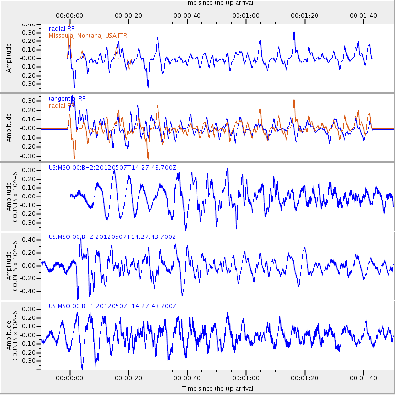
Signal To Noise
| Channel | StoN | STA | LTA |
| US:MSO:00:BHZ:20120507T14:27:43.700Z | 2.5611143 | 2.0544303E-7 | 8.021627E-8 |
| US:MSO:00:BH1:20120507T14:27:43.700Z | 2.1379125 | 1.8953784E-7 | 8.865557E-8 |
| US:MSO:00:BH2:20120507T14:27:43.700Z | 0.8841308 | 1.1928536E-7 | 1.3491824E-7 |
| Arrivals |
| Ps | |
| PpPs | |
| PsPs/PpSs | |


