You are here: Home > Network List > CN - Canadian National Seismograph Network Stations List
> Station PMB Pemberton, British Columbia, Canada > Earthquake Result Viewer
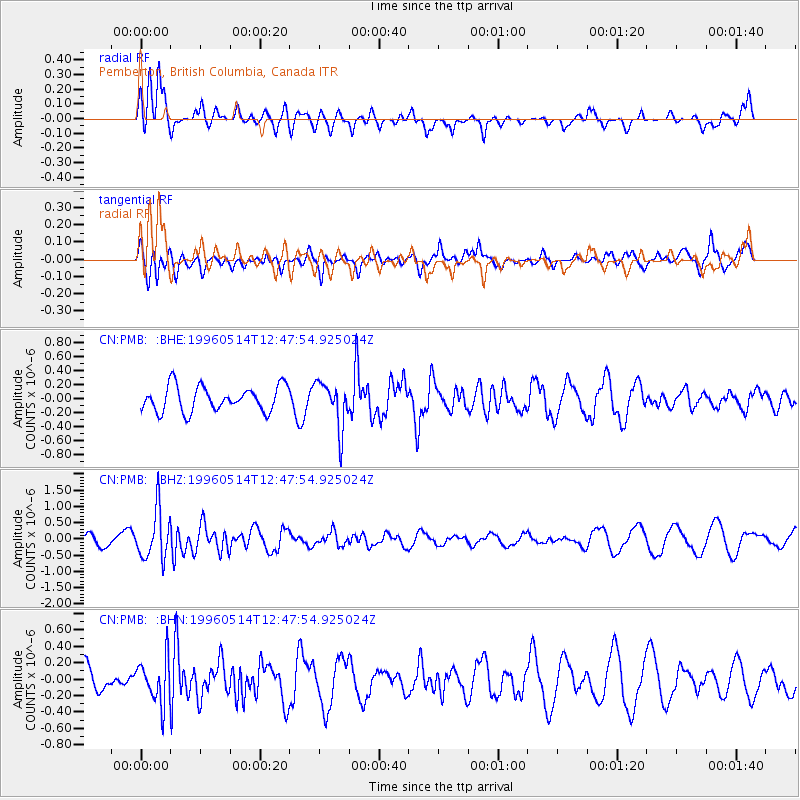
PMB Pemberton, British Columbia, Canada - Earthquake Result Viewer
*The percent match for this event was below the threshold and hence no stack was calculated.
| Earthquake location: |
Fiji Islands Region |
| Earthquake latitude/longitude: |
-18.0/-178.5 |
| Earthquake time(UTC): |
1996/05/14 (135) 12:36:59 GMT |
| Earthquake Depth: |
605 km |
| Earthquake Magnitude: |
5.5 MB, 5.6 UNKNOWN |
| Earthquake Catalog/Contributor: |
WHDF/NEIC |
|
| Network: |
CN Canadian National Seismograph Network |
| Station: |
PMB Pemberton, British Columbia, Canada |
| Lat/Lon: |
50.52 N/123.08 W |
| Elevation: |
400 m |
|
| Distance: |
83.8 deg |
| Az: |
31.94 deg |
| Baz: |
232.08 deg |
| Ray Param: |
$rayparam |
*The percent match for this event was below the threshold and hence was not used in the summary stack. |
|
| Radial Match: |
61.397415 % |
| Radial Bump: |
400 |
| Transverse Match: |
59.381844 % |
| Transverse Bump: |
355 |
| SOD ConfigId: |
4480 |
| Insert Time: |
2010-02-27 06:57:08.100 +0000 |
| GWidth: |
2.5 |
| Max Bumps: |
400 |
| Tol: |
0.001 |
|
Signal To Noise
| Channel | StoN | STA | LTA |
| CN:PMB: :BHZ:19960514T12:47:54.925024Z | 2.555948 | 7.502185E-7 | 2.9351867E-7 |
| CN:PMB: :BHN:19960514T12:47:54.925024Z | 1.5716746 | 2.7084883E-7 | 1.7233137E-7 |
| CN:PMB: :BHE:19960514T12:47:54.925024Z | 1.8478932 | 3.290952E-7 | 1.780921E-7 |
| Arrivals |
| Ps | |
| PpPs | |
| PsPs/PpSs | |


