You are here: Home > Network List > CN - Canadian National Seismograph Network Stations List
> Station PMB Pemberton, British Columbia, Canada > Earthquake Result Viewer
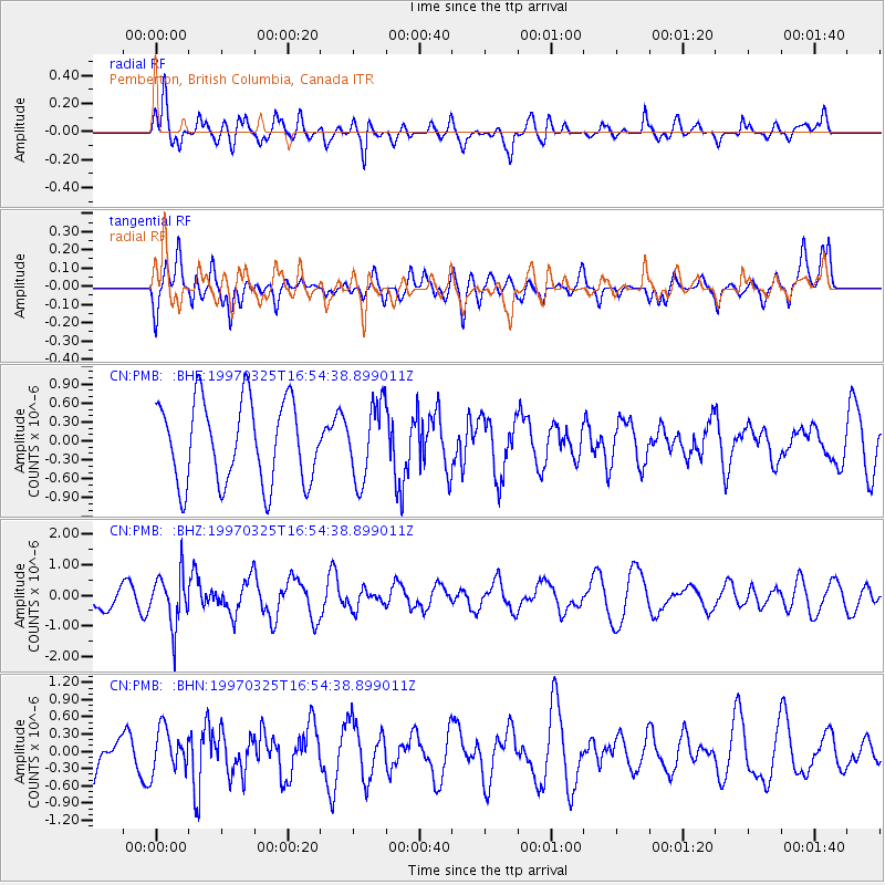
PMB Pemberton, British Columbia, Canada - Earthquake Result Viewer
*The percent match for this event was below the threshold and hence no stack was calculated.
| Earthquake location: |
Peru-Brazil Border Region |
| Earthquake latitude/longitude: |
-9.1/-71.3 |
| Earthquake time(UTC): |
1997/03/25 (084) 16:44:32 GMT |
| Earthquake Depth: |
603 km |
| Earthquake Magnitude: |
6.0 UNKNOWN, 5.4 MB, 6.0 MW |
| Earthquake Catalog/Contributor: |
WHDF/NEIC |
|
| Network: |
CN Canadian National Seismograph Network |
| Station: |
PMB Pemberton, British Columbia, Canada |
| Lat/Lon: |
50.52 N/123.08 W |
| Elevation: |
400 m |
|
| Distance: |
74.4 deg |
| Az: |
328.612 deg |
| Baz: |
126.311 deg |
| Ray Param: |
$rayparam |
*The percent match for this event was below the threshold and hence was not used in the summary stack. |
|
| Radial Match: |
51.812004 % |
| Radial Bump: |
400 |
| Transverse Match: |
71.19769 % |
| Transverse Bump: |
400 |
| SOD ConfigId: |
4480 |
| Insert Time: |
2010-02-27 06:57:09.789 +0000 |
| GWidth: |
2.5 |
| Max Bumps: |
400 |
| Tol: |
0.001 |
|
Signal To Noise
| Channel | StoN | STA | LTA |
| CN:PMB: :BHZ:19970325T16:54:38.899011Z | 1.6832643 | 8.43697E-7 | 5.0122674E-7 |
| CN:PMB: :BHN:19970325T16:54:38.899011Z | 1.056594 | 3.6596322E-7 | 3.4636125E-7 |
| CN:PMB: :BHE:19970325T16:54:38.899011Z | 0.9251685 | 5.994544E-7 | 6.4794074E-7 |
| Arrivals |
| Ps | |
| PpPs | |
| PsPs/PpSs | |


