You are here: Home > Network List > CN - Canadian National Seismograph Network Stations List
> Station PMB Pemberton, British Columbia, Canada > Earthquake Result Viewer
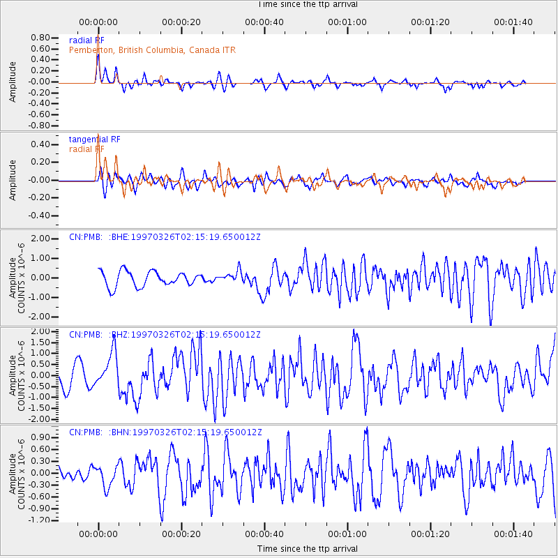
PMB Pemberton, British Columbia, Canada - Earthquake Result Viewer
*The percent match for this event was below the threshold and hence no stack was calculated.
| Earthquake location: |
Rat Islands, Aleutian Islands |
| Earthquake latitude/longitude: |
51.3/179.5 |
| Earthquake time(UTC): |
1997/03/26 (085) 02:08:57 GMT |
| Earthquake Depth: |
33 km |
| Earthquake Magnitude: |
6.0 MB, 6.5 MS, 6.7 UNKNOWN, 6.3 ML |
| Earthquake Catalog/Contributor: |
WHDF/NEIC |
|
| Network: |
CN Canadian National Seismograph Network |
| Station: |
PMB Pemberton, British Columbia, Canada |
| Lat/Lon: |
50.52 N/123.08 W |
| Elevation: |
400 m |
|
| Distance: |
35.4 deg |
| Az: |
68.135 deg |
| Baz: |
294.055 deg |
| Ray Param: |
$rayparam |
*The percent match for this event was below the threshold and hence was not used in the summary stack. |
|
| Radial Match: |
67.45522 % |
| Radial Bump: |
337 |
| Transverse Match: |
62.642166 % |
| Transverse Bump: |
400 |
| SOD ConfigId: |
4480 |
| Insert Time: |
2010-02-27 06:57:11.143 +0000 |
| GWidth: |
2.5 |
| Max Bumps: |
400 |
| Tol: |
0.001 |
|
Signal To Noise
| Channel | StoN | STA | LTA |
| CN:PMB: :BHZ:19970326T02:15:19.650012Z | 1.7018594 | 8.240799E-7 | 4.842233E-7 |
| CN:PMB: :BHN:19970326T02:15:19.650012Z | 1.191457 | 2.6242796E-7 | 2.2025802E-7 |
| CN:PMB: :BHE:19970326T02:15:19.650012Z | 0.8088287 | 3.0768214E-7 | 3.8040457E-7 |
| Arrivals |
| Ps | |
| PpPs | |
| PsPs/PpSs | |


