You are here: Home > Network List > US - United States National Seismic Network Stations List
> Station AMTX Amarillo, Texas, USA > Earthquake Result Viewer
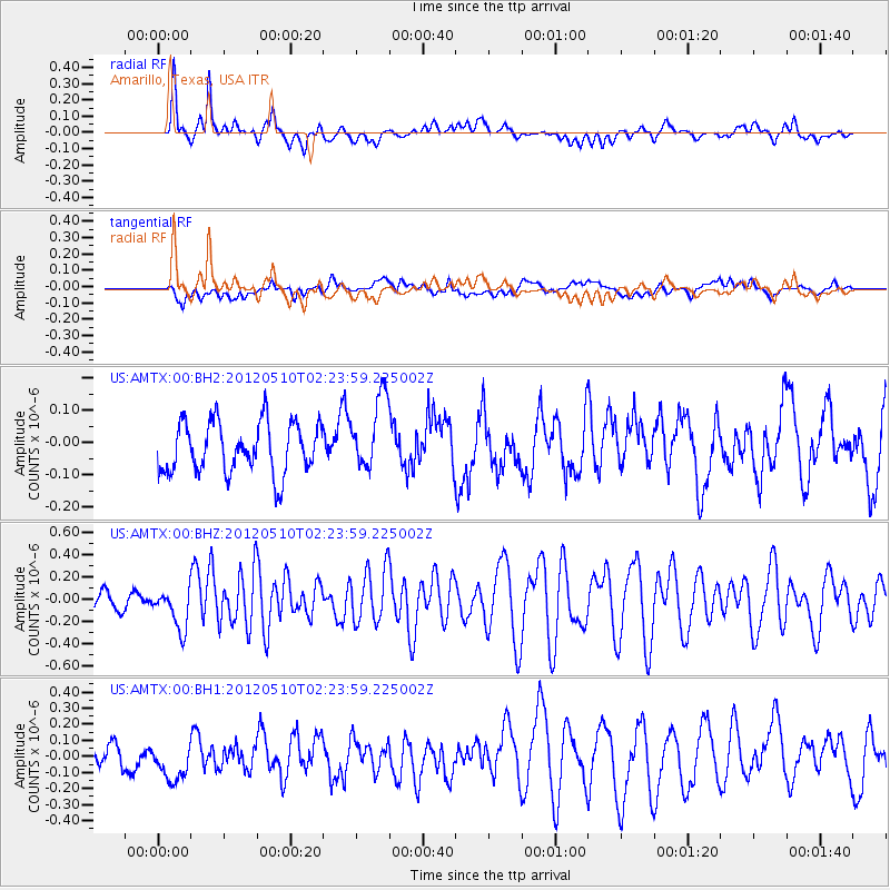
AMTX Amarillo, Texas, USA - Earthquake Result Viewer
*The percent match for this event was below the threshold and hence no stack was calculated.
| Earthquake location: |
Easter Island Region |
| Earthquake latitude/longitude: |
-28.7/-112.6 |
| Earthquake time(UTC): |
2012/05/10 (131) 02:13:56 GMT |
| Earthquake Depth: |
10 km |
| Earthquake Magnitude: |
5.8 MS, 5.3 MB, 5.9 MW, 5.8 MW |
| Earthquake Catalog/Contributor: |
WHDF/NEIC |
|
| Network: |
US United States National Seismic Network |
| Station: |
AMTX Amarillo, Texas, USA |
| Lat/Lon: |
34.53 N/101.41 W |
| Elevation: |
1010 m |
|
| Distance: |
63.8 deg |
| Az: |
10.276 deg |
| Baz: |
190.939 deg |
| Ray Param: |
$rayparam |
*The percent match for this event was below the threshold and hence was not used in the summary stack. |
|
| Radial Match: |
77.088615 % |
| Radial Bump: |
400 |
| Transverse Match: |
39.43606 % |
| Transverse Bump: |
400 |
| SOD ConfigId: |
558545 |
| Insert Time: |
2013-09-19 18:20:49.341 +0000 |
| GWidth: |
2.5 |
| Max Bumps: |
400 |
| Tol: |
0.001 |
|
Signal To Noise
| Channel | StoN | STA | LTA |
| US:AMTX:00:BHZ:20120510T02:23:59.225002Z | 1.7154424 | 1.817595E-7 | 1.0595489E-7 |
| US:AMTX:00:BH1:20120510T02:23:59.225002Z | 1.6244202 | 1.2272567E-7 | 7.5550446E-8 |
| US:AMTX:00:BH2:20120510T02:23:59.225002Z | 1.0595165 | 8.3517655E-8 | 7.882618E-8 |
| Arrivals |
| Ps | |
| PpPs | |
| PsPs/PpSs | |


