You are here: Home > Network List > US - United States National Seismic Network Stations List
> Station CBKS Cedar Bluff, Kansas, USA > Earthquake Result Viewer
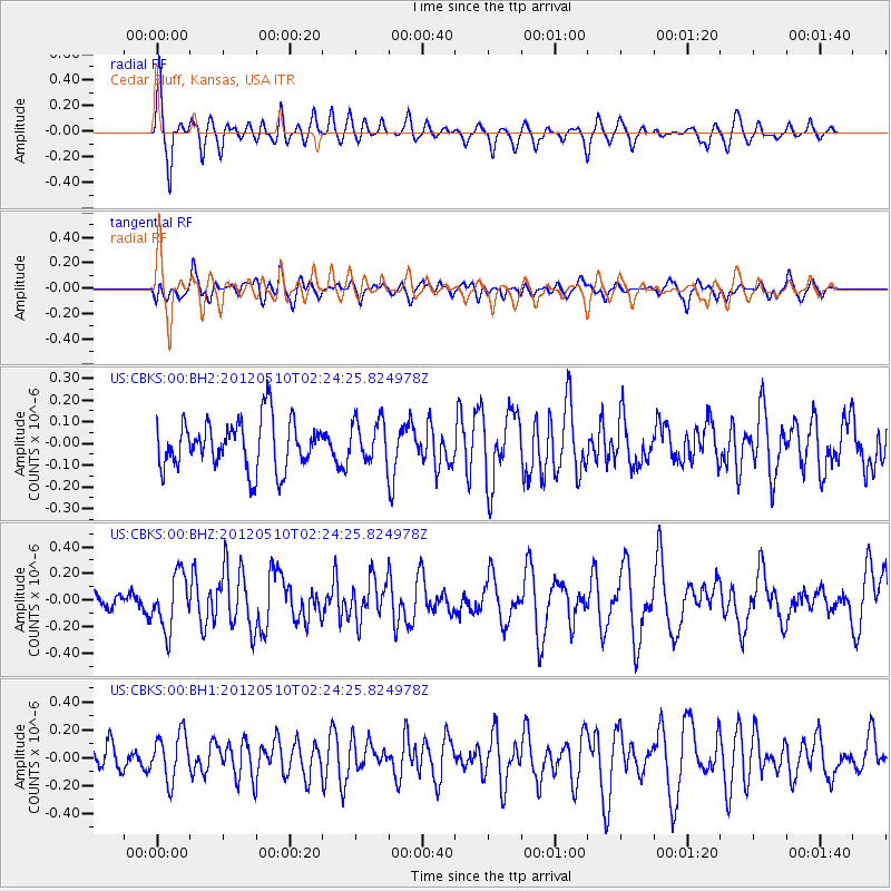
CBKS Cedar Bluff, Kansas, USA - Earthquake Result Viewer
*The percent match for this event was below the threshold and hence no stack was calculated.
| Earthquake location: |
Easter Island Region |
| Earthquake latitude/longitude: |
-28.7/-112.6 |
| Earthquake time(UTC): |
2012/05/10 (131) 02:13:56 GMT |
| Earthquake Depth: |
10 km |
| Earthquake Magnitude: |
5.8 MS, 5.3 MB, 5.9 MW, 5.8 MW |
| Earthquake Catalog/Contributor: |
WHDF/NEIC |
|
| Network: |
US United States National Seismic Network |
| Station: |
CBKS Cedar Bluff, Kansas, USA |
| Lat/Lon: |
38.81 N/99.74 W |
| Elevation: |
677 m |
|
| Distance: |
68.3 deg |
| Az: |
10.781 deg |
| Baz: |
192.138 deg |
| Ray Param: |
$rayparam |
*The percent match for this event was below the threshold and hence was not used in the summary stack. |
|
| Radial Match: |
77.458466 % |
| Radial Bump: |
384 |
| Transverse Match: |
54.90512 % |
| Transverse Bump: |
400 |
| SOD ConfigId: |
558545 |
| Insert Time: |
2013-09-19 18:20:59.365 +0000 |
| GWidth: |
2.5 |
| Max Bumps: |
400 |
| Tol: |
0.001 |
|
Signal To Noise
| Channel | StoN | STA | LTA |
| US:CBKS:00:BHZ:20120510T02:24:25.824978Z | 4.318443 | 2.0702933E-7 | 4.7940738E-8 |
| US:CBKS:00:BH1:20120510T02:24:25.824978Z | 1.7551326 | 1.6656205E-7 | 9.489998E-8 |
| US:CBKS:00:BH2:20120510T02:24:25.824978Z | 0.85282344 | 9.575645E-8 | 1.12281676E-7 |
| Arrivals |
| Ps | |
| PpPs | |
| PsPs/PpSs | |


