You are here: Home > Network List > US - United States National Seismic Network Stations List
> Station EGMT Eagleton, Montana, USA > Earthquake Result Viewer
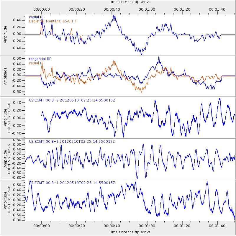
EGMT Eagleton, Montana, USA - Earthquake Result Viewer
*The percent match for this event was below the threshold and hence no stack was calculated.
| Earthquake location: |
Easter Island Region |
| Earthquake latitude/longitude: |
-28.7/-112.6 |
| Earthquake time(UTC): |
2012/05/10 (131) 02:13:56 GMT |
| Earthquake Depth: |
10 km |
| Earthquake Magnitude: |
5.8 MS, 5.3 MB, 5.9 MW, 5.8 MW |
| Earthquake Catalog/Contributor: |
WHDF/NEIC |
|
| Network: |
US United States National Seismic Network |
| Station: |
EGMT Eagleton, Montana, USA |
| Lat/Lon: |
48.02 N/109.75 W |
| Elevation: |
1055 m |
|
| Distance: |
76.4 deg |
| Az: |
1.955 deg |
| Baz: |
182.559 deg |
| Ray Param: |
$rayparam |
*The percent match for this event was below the threshold and hence was not used in the summary stack. |
|
| Radial Match: |
47.254547 % |
| Radial Bump: |
400 |
| Transverse Match: |
39.906857 % |
| Transverse Bump: |
400 |
| SOD ConfigId: |
558545 |
| Insert Time: |
2013-09-19 18:21:11.414 +0000 |
| GWidth: |
2.5 |
| Max Bumps: |
400 |
| Tol: |
0.001 |
|
Signal To Noise
| Channel | StoN | STA | LTA |
| US:EGMT:00:BHZ:20120510T02:25:14.550015Z | 1.8734359 | 2.296295E-7 | 1.2257132E-7 |
| US:EGMT:00:BH1:20120510T02:25:14.550015Z | 0.66018975 | 2.4090866E-7 | 3.6490823E-7 |
| US:EGMT:00:BH2:20120510T02:25:14.550015Z | 0.9701948 | 1.2262139E-7 | 1.2638841E-7 |
| Arrivals |
| Ps | |
| PpPs | |
| PsPs/PpSs | |


