You are here: Home > Network List > US - United States National Seismic Network Stations List
> Station HAWA Hanford, Washington, USA > Earthquake Result Viewer
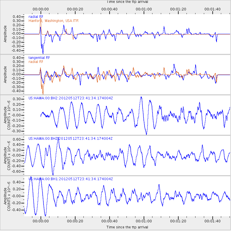
HAWA Hanford, Washington, USA - Earthquake Result Viewer
*The percent match for this event was below the threshold and hence no stack was calculated.
| Earthquake location: |
Afghanistan-Tajikistan Bord Reg. |
| Earthquake latitude/longitude: |
38.6/70.4 |
| Earthquake time(UTC): |
2012/05/12 (133) 23:28:43 GMT |
| Earthquake Depth: |
10 km |
| Earthquake Magnitude: |
6.0 MB, 5.7 MS, 5.7 MW, 5.9 MW |
| Earthquake Catalog/Contributor: |
WHDF/NEIC |
|
| Network: |
US United States National Seismic Network |
| Station: |
HAWA Hanford, Washington, USA |
| Lat/Lon: |
46.39 N/119.53 W |
| Elevation: |
364 m |
|
| Distance: |
94.9 deg |
| Az: |
6.85 deg |
| Baz: |
352.241 deg |
| Ray Param: |
$rayparam |
*The percent match for this event was below the threshold and hence was not used in the summary stack. |
|
| Radial Match: |
53.805874 % |
| Radial Bump: |
400 |
| Transverse Match: |
61.937317 % |
| Transverse Bump: |
400 |
| SOD ConfigId: |
558545 |
| Insert Time: |
2013-09-19 18:25:04.387 +0000 |
| GWidth: |
2.5 |
| Max Bumps: |
400 |
| Tol: |
0.001 |
|
Signal To Noise
| Channel | StoN | STA | LTA |
| US:HAWA:00:BHZ:20120512T23:41:34.174004Z | 1.8415785 | 2.6853962E-7 | 1.4582035E-7 |
| US:HAWA:00:BH1:20120512T23:41:34.174004Z | 1.7303343 | 3.7436823E-7 | 2.1635601E-7 |
| US:HAWA:00:BH2:20120512T23:41:34.174004Z | 0.8887635 | 1.1766901E-7 | 1.3239631E-7 |
| Arrivals |
| Ps | |
| PpPs | |
| PsPs/PpSs | |


